Haro and Rosario Straits.

Haro and Rosario Straits.
North-West American Water Boundary (San Juan). Maps (5), annexed to the case of the Government of Her Britannic Majesty submitted to the arbitration and award of H.M. the Emperor of Germany, in accordance with Article 34 of the Treaty between Great Britain and the United States of America. Signed at Washington 8th May, 1871. (3 copies.) Author, Publisher, &c.: Official, London. [Haro and Rosario Straits, 1859; 1871]. At head of title: North America, west coast. Surveyed by Captn. G.H. Richards, & the Officers of H.M.S. Plumper 1858-9. Drawn for engraving by E.J. Powell. Engraved by J. & C. Walker. The shores of Juan de Fuca Strait to Admiralty Inlet from Captn. H. Kellett's survey, 1847. The east coast of Rosario Strait from Bellingham Bay to Admiralty Inlet taken from the American surveys of 1841. First published 1859 updated and corrected. Latest date on map 1871. Relief shown by hachures and spot heights; depths shown by soundings in fathoms. Includes side views of various landmarks.
Richards, G. H. (George Henry), Haro and Rosario Straits, 1859-1865, Great Britain. Hydrographic Service, CO700-CANADA125 (6). The Colonial Despatches of Vancouver Island and British Columbia 1846-1871, Edition 2.4, ed. James Hendrickson and the Colonial Despatches project. Victoria, B.C.: University of Victoria. https://bcgenesis.uvic.ca/co_700-canada_125_6_1859_1865_haro_and_rosario_ss.html.

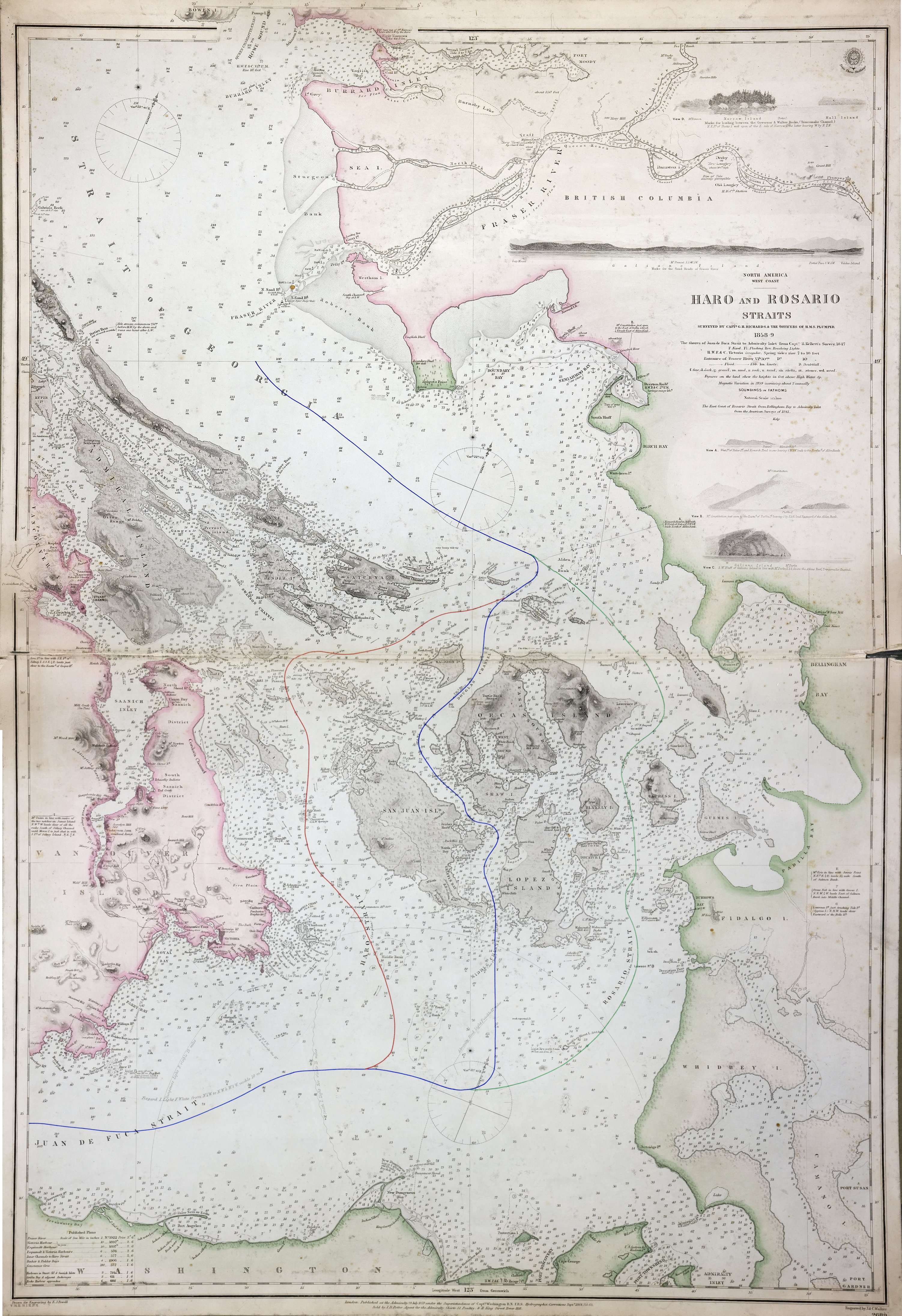
Title: Haro and Rosario Straits.

Title: North America, west coast, Haro and Rosario Straits.

Author: Richards, G. H. (George Henry)

Subject: Nautical charts -- Haro Strait (B.C. and Wash.); Nautical charts -- British Columbia -- Gulf Islands; Nautical charts -- Washington (State) -- Rosario Strait; Nautical charts -- Washington (State) -- San Juan Islands; San Juan Boundary Dispute, 1846-1872.

Subject: Haro and Rosario Straits, 1859, 1871

Identifier (repository): CO

Identifier (repoNumber): 700

Identifier (repoVol): canada

Identifier (libFileName): CO700-CANADA125 (6)

Identifier (penfoldNum): 489

Identifier (doc_id): CO700-CANADA125 (6)

Date: 1865

Funder: Funded by a Canadian Council of Archives, Archival Community Digitization Program.

Publisher: Great Britain. Hydrographic Service.

Publisher: National Archives of the UK.

Identifier (CONTENTdm): oai:contentdm.library.uvic.ca:collection5/54

49 19'N-N 48 5'/ 123 39'W-122 25'W.