Sketch of the entrance of the Strait of Juan de Fuca : Lat. 48 37' N. Long. 124 54' W. : Variation observed 19

Sketch of the entrance of the Strait of Juan de Fuca : Lat. 48 37' N. Long. 124 54' W. : Variation observed 19
Plans of Ports and Harbours on the North West Coast of America. Published by A. Dalrymple, London. [Juan de Fuca, Strait, 1788; 1790]. By Charles Duncan, Master in the Royal Navy, 15th August 1788. Published Jan. 14th, 1790. J. Walker, Sculpt; W. Harrison. Descriptive text contains some comments on the Indians of Cape Claaset (Cape Flattery, Wash.). It also includes a drawing of Pinnacle Rock (Fuca’s Pillar, Wash.), off the cape.
Duncan, Charles, fl. 1782-96, Sketch of the entrance of the Strait of Juan de Fuca : Lat. 48 37' N. Long. 124 54' W. : Variation observed 19, 1790, Dalrymple, Alexander, 1737-1808, CO 700/AMERICA NORTH AND SOUTH51. The Colonial Despatches of Vancouver Island and British Columbia 1846-1871, Edition 2.4, ed. James Hendrickson and the Colonial Despatches project. Victoria, B.C.: University of Victoria. https://bcgenesis.uvic.ca/co_700-america_north_and_south_51_26_j_d_f_entrance_1790.html.

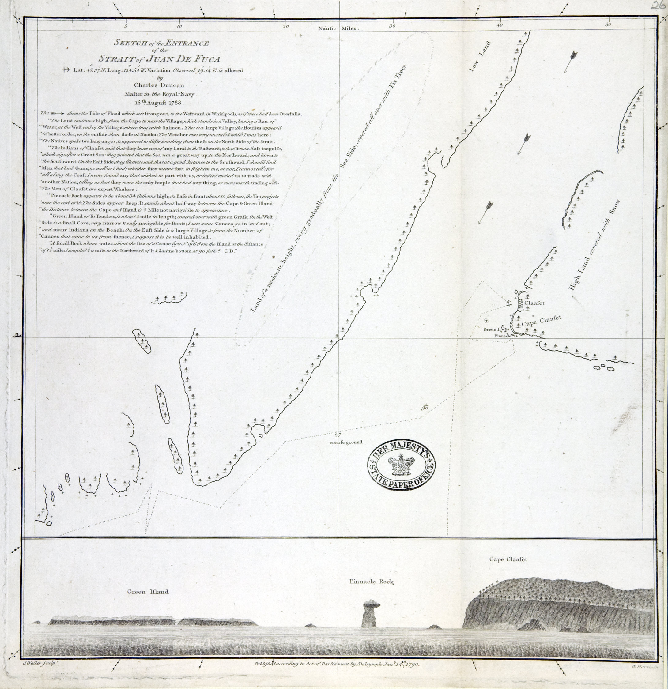
Title: Sketch of the entrance of the Strait of Juan de Fuca : Lat. 48 37' N. Long. 124 54' W. : Variation observed 19

Title: Entrance of the Strait of Juan de Fuca

Author: Duncan, Charles, fl. 1782-96

Subject: Juan de Fuca Strait (B.C. and Wash.) -- Maps; Flattery, Cape (Wash.) -- Maps. Indians of North America -- Washington (State)

Subject: Juan de Fuca, Strait, 1788, 1790

Identifier (repository): CO

Identifier (repoNumber): 700

Identifier (repoVol): america

Identifier (libFileName): CO700-AMERICA NORTH and SOUTH51 (26)

Identifier (penfoldNum): 496

Identifier (doc_id): CO 700/AMERICA NORTH AND SOUTH51

Date: 1790

Funder: Funded by a Canadian Council of Archives, Archival Community Digitization Program.

Publisher: Dalrymple, Alexander, 1737-1808

Publisher: National Archives of the UK.

Identifier (CONTENTdm): oai:contentdm.library.uvic.ca:collection5/10