British Columbia, 1862. Coast lines from Admiralty charts, interior from explorations by Royal Engineers and others up to 1862. North of Fraser River from Mr. Arrowsmith, East of Columbia River from Captain Palliser.

British Columbia, 1862. Coast lines from Admiralty charts, interior from explorations by Royal Engineers and others up to 1862. North of Fraser River from Mr. Arrowsmith, East of Columbia River from Captain Palliser.
Map of British Columbia. Prepared under the direction of Captain Parsons, R.E., at the Office of Lands and Works, New Westminster, August, 1862. 50 miles to 1 inch. [British Columbia, 1862]. 
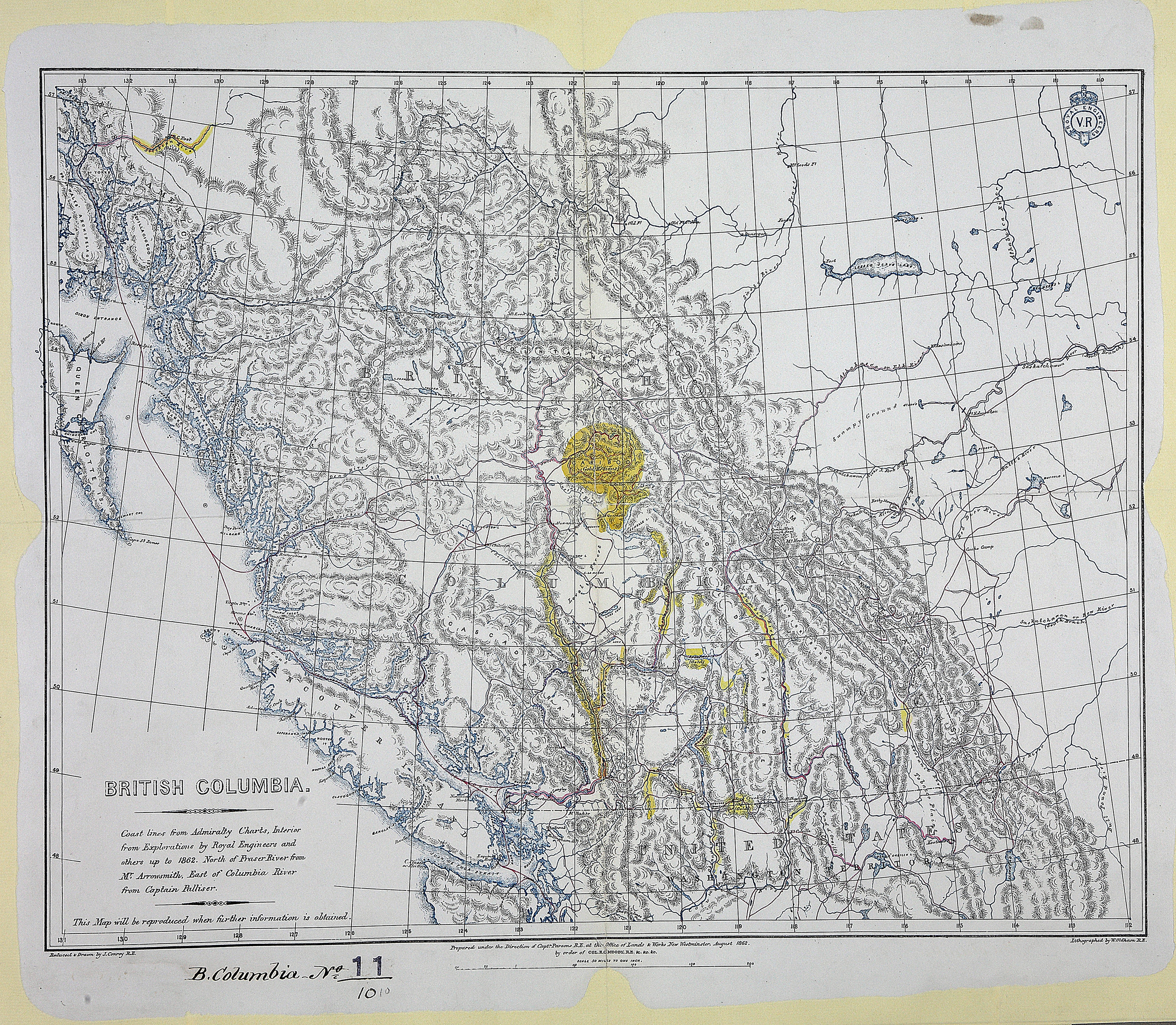
This map will be reproduced when further information is available. Gold regions marked in yellow. Reduced & drawn by J. Conroy R.E. Lithographed by W. Oldham R.E.
Conroy, James., British Columbia, 1862. Coast lines from Admiralty charts, interior from explorations by Royal Engineers and others up to 1862. North of Fraser River from Mr. Arrowsmith, East of Columbia River from Captain Palliser, 1862, British Columbia. Dept. of Lands and Works, CO700-BRITISH COLUMBIA11 (10). The Colonial Despatches of Vancouver Island and British Columbia 1846-1871, Edition 2.4, ed. James Hendrickson and the Colonial Despatches project. Victoria, B.C.: University of Victoria. https://bcgenesis.uvic.ca/co_700-bc_11_10_bc_1862.html.

Title: British Columbia, 1862. Coast lines from Admiralty charts, interior from explorations by Royal Engineers and others up to 1862. North of Fraser River from Mr. Arrowsmith, East of Columbia River from Captain Palliser.

Author: Conroy, James.

Subject: British Columbia -- Maps; Gold mines and mining -- British Columbia -- Maps.

Subject: British Columbia, 1862

Identifier (repository): CO

Identifier (repoNumber): 700

Identifier (repoVol): bc

Identifier (libFileName): CO700-BRITISH COLUMBIA11 (10)

Identifier (penfoldNum): 404

Identifier (doc_id): CO700-BRITISH COLUMBIA11 (10)

Date: 1862

Funder: Funded by a Canadian Council of Archives, Archival Community Digitization Program.

Publisher: British Columbia. Dept. of Lands and Works.

Publisher: National Archives of the UK.

Identifier (CONTENTdm): oai:contentdm.library.uvic.ca:collection5/183

57N-48N/131W-110W
Conroy, James., British Columbia, 1862. Coast lines from Admiralty charts, interior from explorations by Royal Engineers and others up to 1862. North of Fraser River from Mr. Arrowsmith, East of Columbia River from Captain Palliser, 1862, British Columbia. Dept. of Lands and Works, CO700-BRITISH COLUMBIA11 (10). The Colonial Despatches of Vancouver Island and British Columbia 1846-1871, Edition 2.4, ed. James Hendrickson and the Colonial Despatches project. Victoria, B.C.: University of Victoria. https://bcgenesis.uvic.ca/co_700-bc_11_10_bc_1862.html.
Last modified: 2022-12-15 13:24:22 -0800 (Thu, 15 Dec 2022) (SVN revision: 5648)