Colonial Despatches
The colonial despatches of Vancouver Island and British Columbia 1846-1871
New Westminster to Lillooet, from a general Map in preparation by Royal Engineers.
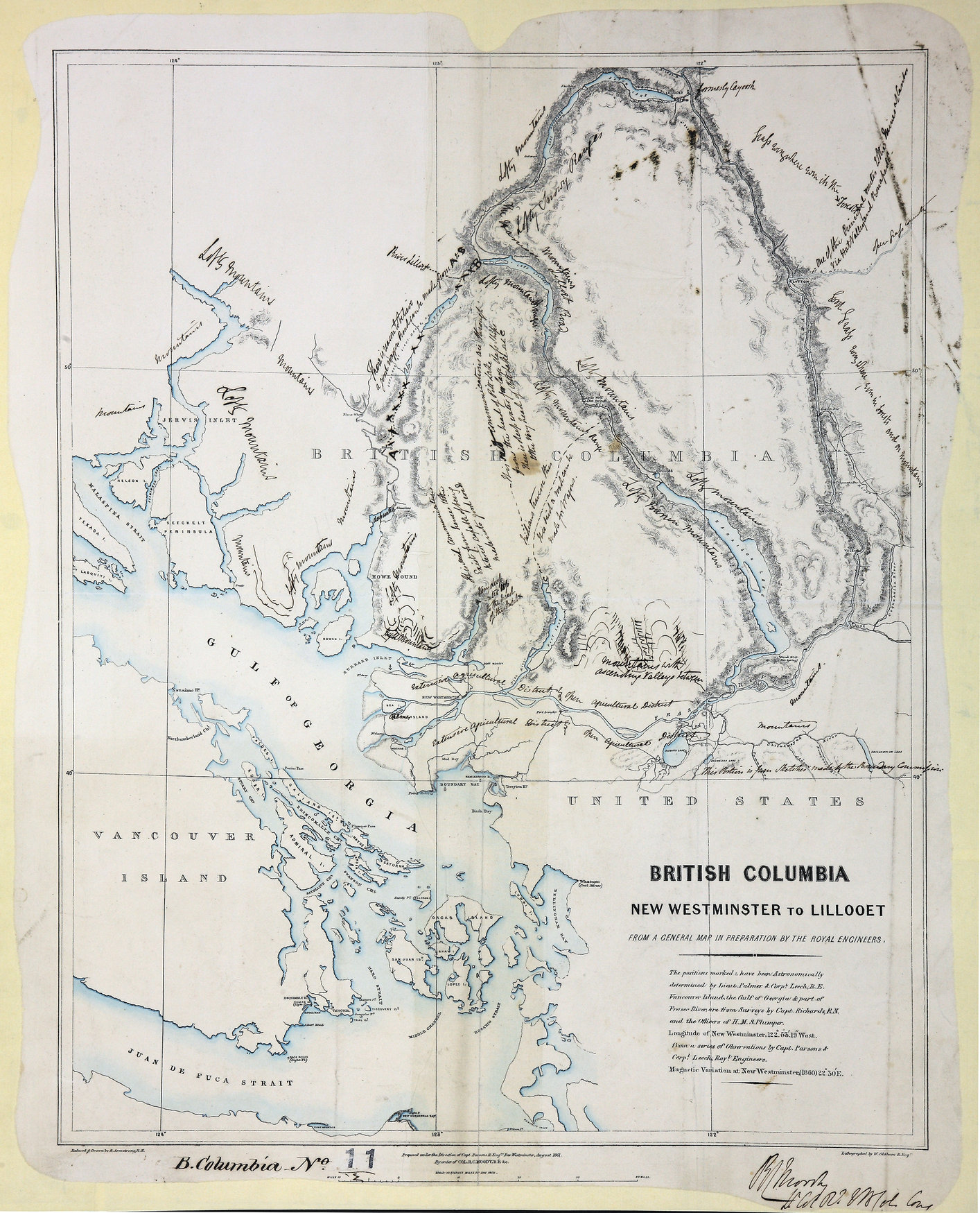
New Westminster to Lillooet, from a general Map in preparation by Royal Engineers.
10 miles to 1 inch. New Westminster. [British Columbia, 1861]. Manuscript notes all
over map. Notes probably by R.M. Parsons. Reduced & drawn by R. Armstrong R.E.; Lithographed
by W. Oldham, R.E.; Prepared under the direction of Capt. Parsons, R. Eng., New Westminster
August 1861. See related letter: The Fraser River is at present the only means of
access to the interior of British Columbia without passing through foreign territory.
Armstrong, Robert, New Westminster to Lillooet, from a general Map in preparation by Royal Engineers, 1861, Great Britain. Army. Royal Engineers. Columbia Detachment, CO 700/BRITISH
COLUMBIA11/2. The Colonial Despatches of Vancouver Island and British Columbia 1846-1871, Edition 2.6, ed. James Hendrickson and the Colonial Despatches project. Victoria,
B.C.: University of Victoria. https://bcgenesis.uvic.ca/co_700-bc_11_2_new_west_lillooet_1861.html.
Title: New Westminster to Lillooet, from a general Map in preparation by Royal Engineers.
Author: Armstrong, Robert
Subject: British Columbia -- Maps; Highway planning -- British Columbia
Subject: British Columbia, 1861
Identifier (repository): CO
Identifier (repoNumber): 700
Identifier (repoVol): bc
Identifier (libFileName): CO700-BRITISH COLUMBIA11 (2)
Identifier (penfoldNum): 399
Identifier (doc_id): CO 700/BRITISH COLUMBIA11/2
Date: 1861
Funder: Funded by a Canadian Council of Archives, Archival Community Digitization Program.
Publisher: Great Britain. Army. Royal Engineers. Columbia Detachment.
Publisher: National Archives of the UK.
50N-49N/124W-122W