Colonial Despatches
The colonial despatches of Vancouver Island and British Columbia 1846-1871
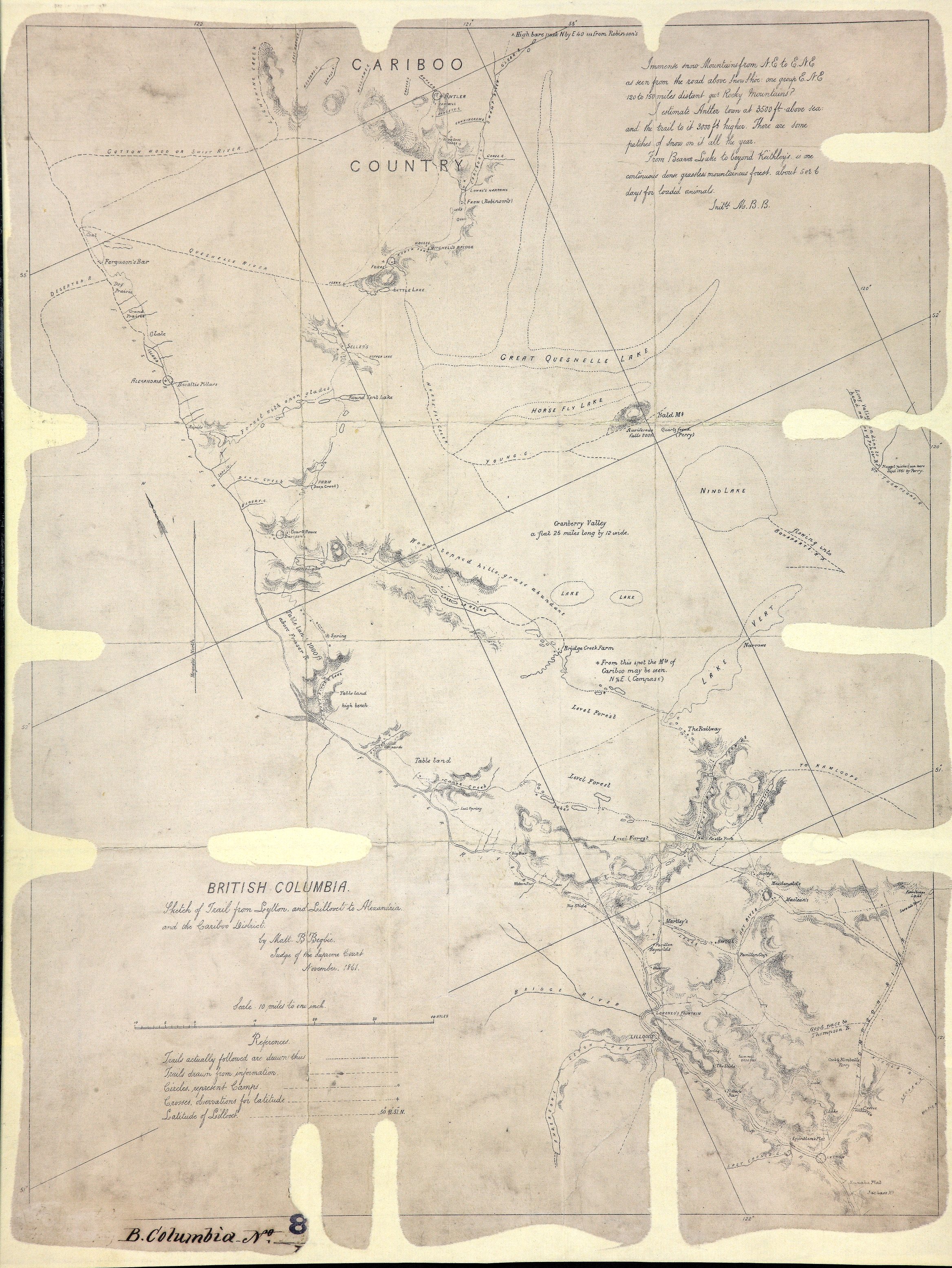
Sketch of trail from Lytton and Lillooet to Alexandria and the Cariboo District.
Sketch of Trail from Lytton and Lillooet to Alexandria and the Cariboo District. By
Matt. B. Begbie, Judge of the Supreme Court, [New Westminster], November, 1861. 10
miles to 1 inch. [British Columbia, 1861].
Descriptive text; camps and trails marked. Observations by Judge Begbie written on
the map are transcribed in the transcript box.
Immense snow mountains NE and ENE as seen from the road above Snow Shoe: one group ENE 120 to 150 miles distant qur[?] Rocky Mountains?
I estimate Antler town at 3500ft above sea; and the trail to it 3000ft higher. There are some patches of snow on it all the year.
From Beaver Lake to beyond Keithley's is one continuous dense, grassless mountainous forest, about 5 or 6 days for loaded animals.
Initld. M.B.B.
Begbie, Matthew Baillie, Sir, 1819-1894, Sketch of trail from Lytton and Lillooet to Alexandria and the Cariboo District, 1861, National Archives of the UK, CO 700/BRITISH COLUMBIA8/7. The Colonial Despatches of Vancouver Island and British Columbia 1846-1871, Edition 2.6, ed. James Hendrickson and the Colonial Despatches project. Victoria,
B.C.: University of Victoria. https://bcgenesis.uvic.ca/co_700-bc_8_7_bc_1861.html.
Title: Sketch of trail from Lytton and Lillooet to Alexandria and the Cariboo District.
Author: Begbie, Matthew Baillie, Sir, 1819-1894
Subject: British Columbia -- Maps; Lytton (B.C.) -- Maps; Lillooet (B.C.) -- Maps; Cariboo Region (B.C.) -- Maps; Fort Alexandria National Historic Site (B.C.) -- Maps.
Subject: British Columbia, 1861
Identifier (repository): CO
Identifier (repoNumber): 700
Identifier (repoVol): bc
Identifier (libFileName): CO700-BRITISH COLUMBIA8 (7)
Identifier (penfoldNum): 397
Identifier (doc_id): CO 700/BRITISH COLUMBIA8/7
Date: 1861
Funder: Funded by a Canadian Council of Archives, Archival Community Digitization Program.
Publisher: National Archives of the UK.
53N--51N / 122W--121W