Strait of Juan de Fuca and the channels between the continent & Vancouver Id., showing the boundary line between British & American possessions.

Strait of Juan de Fuca and the channels between the continent & Vancouver Id., showing the boundary line between British & American possessions.
North-West American Water Boundary (San Juan). Maps (5), annexed to the case of the Government of Her Britannic Majesty submitted to the arbitration and award of H.M. the Emperor of Germany, in accordance with Article 34 of the Treaty between Great Britain and the United States of America. Signed at Washington 8th May, 1871. (3 copies.) Author, Publisher, &c.: Official, London. [Juan de Fuca, Strait, 1872; 1873]. Scale not given. From the Admiralty Surveys by Captains H. Kellett, R.N., 1847 & G.H. Richards, R.N., 1858-62. At head of title: North America, west coast. Drawn by Edward J. Powell of the Hydrographic Office. Malby & Sons, Lith. Depths shown by soundings in fathoms. Relief shown by hachures and spot heights. Shows detailed topography and bathymetry of the Straits of Juan de Fuca and waters between Straits of Georgia and Admiralty Inlet. Identifies islands, coastal features, reefs. banks, kelp beds, point of anchorage and mountain peaks. Also gives information on lighthouses, bottom types and tides. Boundary line is shaded red on the side of British possessions, blue on the side of the American possessions. MS note transcribed below.
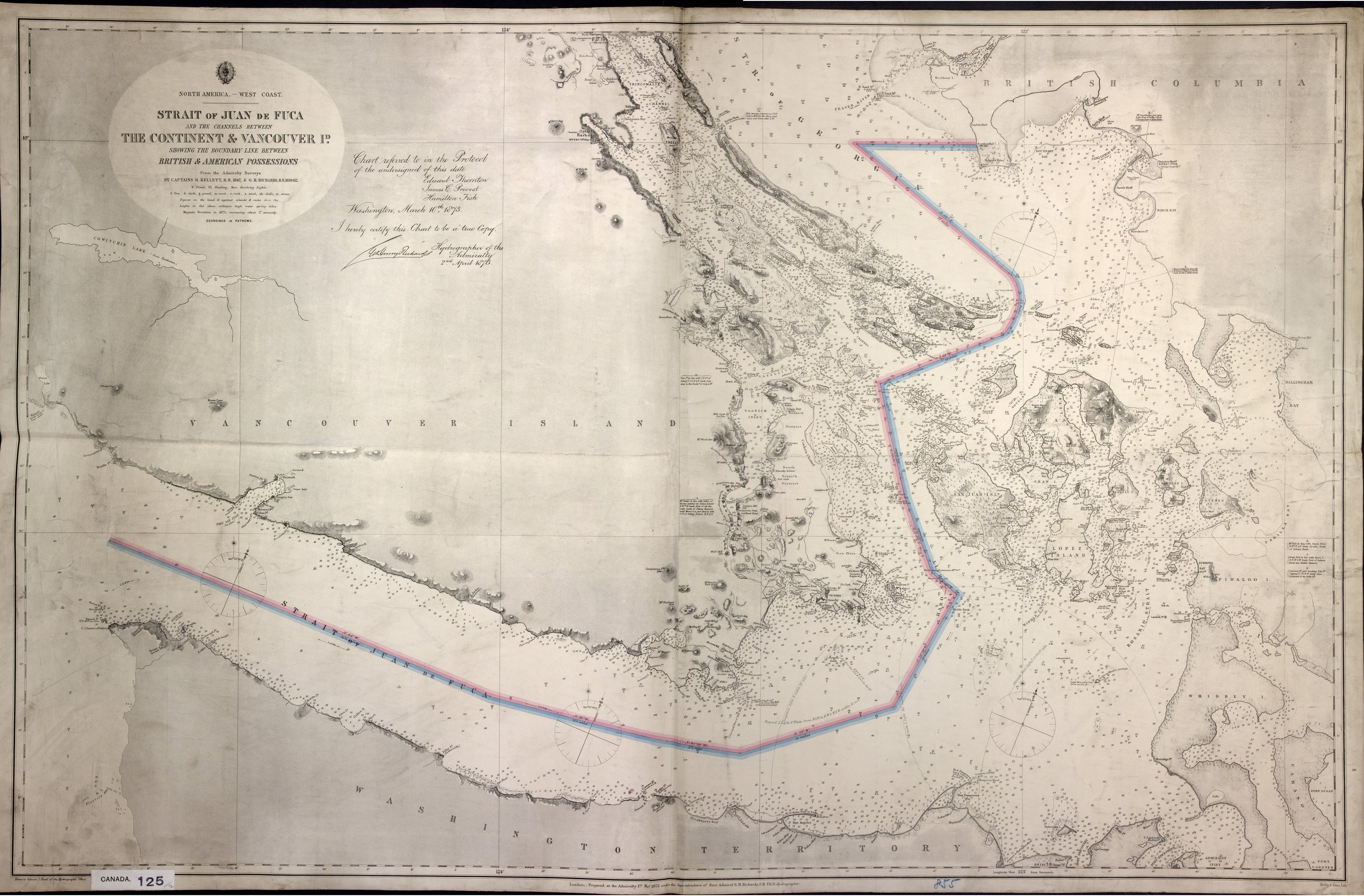
Chart referred to in the Protocol of the undersigned of this date, Edward Thornton, James C. Prevost, Hamilton Fish, Washington, March 10th, 1873. I hereby certify this chart to be a true copy [signed] Geo. Henry Richards, Hydrographer of the Admiralty, 2nd April, 1873.
Powel, E. J., Strait of Juan de Fuca and the channels between the continent & Vancouver Id., showing the boundary line between British & American possessions, 1872, Great Britain. Hydrographic Office, CO700-CANADA125 (11). The Colonial Despatches of Vancouver Island and British Columbia 1846-1871, Edition 2.4, ed. James Hendrickson and the Colonial Despatches project. Victoria, B.C.: University of Victoria. https://bcgenesis.uvic.ca/co_700-canada_125_11_1872_j_d_f_s.html.

Title: Strait of Juan de Fuca and the channels between the continent & Vancouver Id., showing the boundary line between British & American possessions.

Author: Powel, E. J.

Subject: Juan de Fuca Strait (B.C. and Wash.) -- Maps; Georgia, Strait of (B.C. and Wash.) -- Maps; Vancouver Island (B.C.) -- Maps; Nautical charts -- Georgia, Strait of (B.C. and Wash.); Nautical charts -- Juan de Fuca Strait (B.C. and Wash.); Nautical charts – Haro Strait (B.C. and Wash.); San Juan Boundary Dispute, 1846-1872

Subject: Juan de Fuca, Strait, 1872, 1873

Identifier (repository): CO

Identifier (repoNumber): 700

Identifier (repoVol): canada

Identifier (libFileName): CO700-CANADA125 (11)

Identifier (penfoldNum): 523

Identifier (doc_id): CO700-CANADA125 (11)

Date: 1872

Funder: Funded by a Canadian Council of Archives, Archival Community Digitization Program.

Publisher: Great Britain. Hydrographic Office.

Publisher: National Archives of the UK.

Identifier (CONTENTdm): oai:contentdm.library.uvic.ca:collection5/113

49 05'N-48 05'N/124 50'W-122 25'W