Chart shewing part of the coast of N.W. America : with the tracks of His Majesty's sloop Discovery and armed tender Chatham commanded by George Vancouver, esqr. and prepared under his immediate inspection by Lieut. Joseph Baker, in which the continental shore has been traced and determined from lat: 45⁰,30ʹ N. and long. 236⁰,12ʹ E. to lat: 52⁰,15ʹ N. and long. 232⁰,40ʹ E. at the different periods shewn by the tracks ; Warner, sculp

Chart shewing part of the coast of N.W. America : with the tracks of His Majesty's sloop Discovery and armed tender Chatham commanded by George Vancouver, esqr. and prepared under his immediate inspection by Lieut. Joseph Baker, in which the continental shore has been traced and determined from lat: 45⁰,30ʹ N. and long. 236⁰,12ʹ E. to lat: 52⁰,15ʹ N. and long. 232⁰,40ʹ E. at the different periods shewn by the tracks ; Warner, sculp
North-West American Water Boundary (San Juan). Maps (5), annexed to the case of the Government of Her Britannic Majesty submitted to the arbitration and award of H.M. the Emperor of Germany, in accordance with Article 34 of the Treaty between Great Britain and the United States of America. Signed at Washington 8th May, 1871. (3 copies.) Author, Publisher, &c.: Official, London. [British Columbia, Washington, 1798; 1871]. John Warner Sculpt. At bottom of map: 
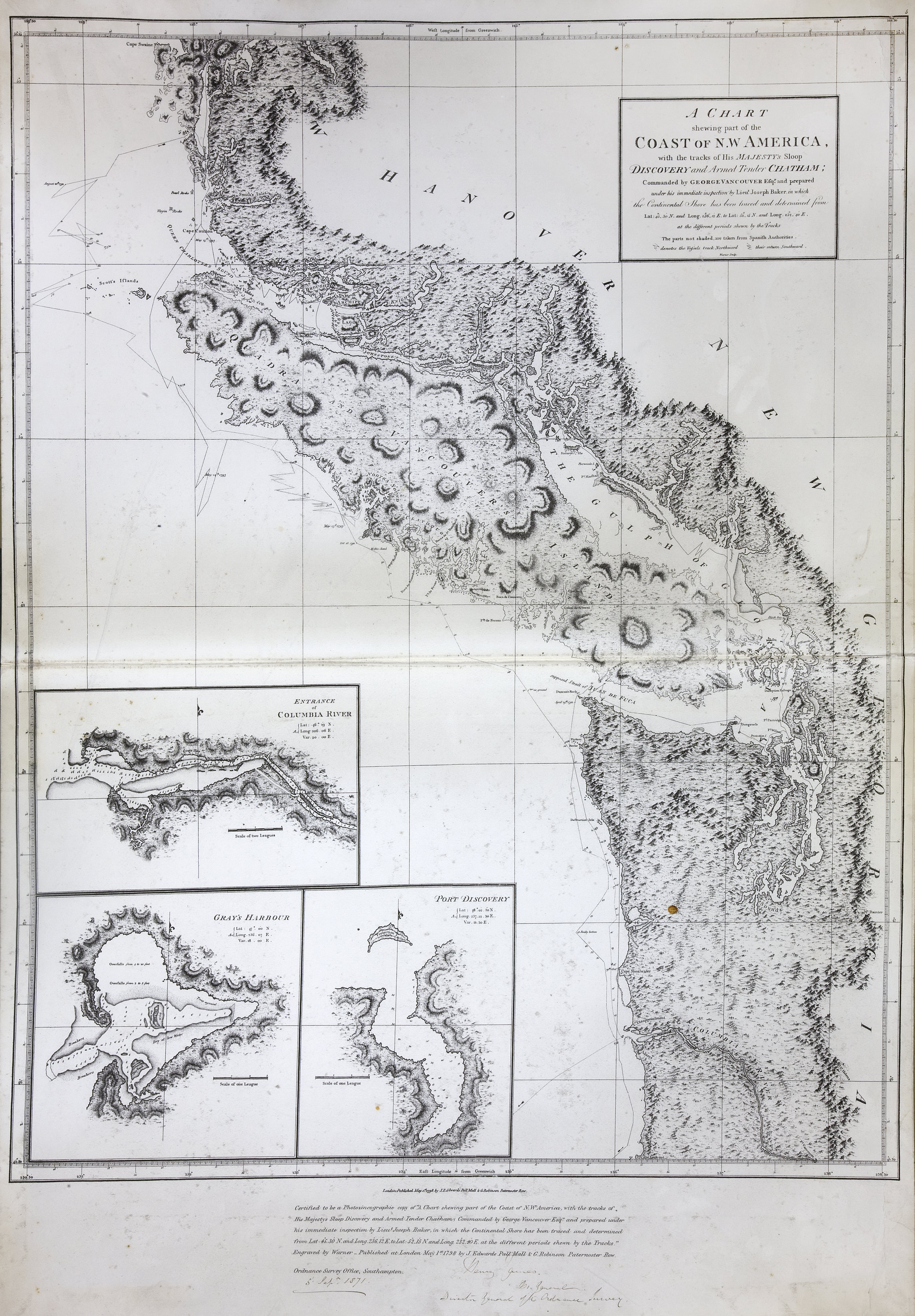
Certified to be a true photozincographic facsimile of A chart shewing part of the coast of N.W. America…Published at London May 1st 1798 J. Eddwards [sic] Pall Mall & G. Robinson, Paternoster Row. Ordnance Survey Office, Southampton, 5 Sept. 1871. Signed Henry James, M. Gen. Director General of the Ordnance Survey. Insets: Entrance of Columbia River. Gray's Harbour. Port Discovery. Relief shown pictorially and by hachures; depths by soundings.
Vancouver, George, 1757-1798, Chart shewing part of the coast of N.W. America : with the tracks of His Majesty's sloop Discovery and armed tender Chatham commanded by George Vancouver, esqr. and prepared under his immediate inspection by Lieut. Joseph Baker, in which the continental shore has been traced and determined from lat: 45⁰,30ʹ N. and long. 236⁰,12ʹ E. to lat: 52⁰,15ʹ N. and long. 232⁰,40ʹ E. at the different periods shewn by the tracks ; Warner, sculp, 1798-1871, Great Britain. Ordnance Survey, CO 700/CANADA125/1. The Colonial Despatches of Vancouver Island and British Columbia 1846-1871, Edition 2.4, ed. James Hendrickson and the Colonial Despatches project. Victoria, B.C.: University of Victoria. https://bcgenesis.uvic.ca/co_700-canada_125_4_1798_1871_van_isl_van.html.

Title: Chart shewing part of the coast of N.W. America : with the tracks of His Majesty's sloop Discovery and armed tender Chatham commanded by George Vancouver, esqr. and prepared under his immediate inspection by Lieut. Joseph Baker, in which the continental shore has been traced and determined from lat: 45⁰,30ʹ N. and long. 236⁰,12ʹ E. to lat: 52⁰,15ʹ N. and long. 232⁰,40ʹ E. at the different periods shewn by the tracks ; Warner, sculp

Author: Vancouver, George, 1757-1798

Subject: Juan de Fuca Strait (B.C. and Wash.) -- Maps; Vancouver Island (B.C.) -- Maps; San Juan Boundary Dispute, 1846-1872; Coasts -- British Columbia -- Maps; Coasts -- Washington (State) -- Maps

Subject: British Columbia, Washington, 1798, 1871

Identifier (repository): CO

Identifier (repoNumber): 700

Identifier (repoVol): canada

Identifier (libFileName): CO700-CANADA125 (4)

Identifier (penfoldNum): 369

Identifier (doc_id): CO 700/CANADA125/1

Date: 1798

Funder: Funded by a Canadian Council of Archives, Archival Community Digitization Program.

Publisher: Great Britain. Ordnance Survey.

Publisher: National Archives of the UK.

Identifier (CONTENTdm): oai:contentdm.library.uvic.ca:collection5/224

52 15'N-45 30'N/129 30'W-122 30'W.
Vancouver, George, 1757-1798, Chart shewing part of the coast of N.W. America : with the tracks of His Majesty's sloop Discovery and armed tender Chatham commanded by George Vancouver, esqr. and prepared under his immediate inspection by Lieut. Joseph Baker, in which the continental shore has been traced and determined from lat: 45⁰,30ʹ N. and long. 236⁰,12ʹ E. to lat: 52⁰,15ʹ N. and long. 232⁰,40ʹ E. at the different periods shewn by the tracks ; Warner, sculp, 1798-1871, Great Britain. Ordnance Survey, CO 700/CANADA125/1. The Colonial Despatches of Vancouver Island and British Columbia 1846-1871, Edition 2.4, ed. James Hendrickson and the Colonial Despatches project. Victoria, B.C.: University of Victoria. https://bcgenesis.uvic.ca/co_700-canada_125_4_1798_1871_van_isl_van.html.
Last modified: 2022-12-15 13:24:22 -0800 (Thu, 15 Dec 2022) (SVN revision: 5648)