Strait of Juan de Fuca surveyed by Captain Henry Kellett, R.N., 1847, Haro & Rosario Straits by Captain G.H. Richards, R.N. 1858, Admiralty Inlet and Puget Sound by the United States exploring expedition, 1841, coast south of Cape Flattery by the same in 1853.

Strait of Juan de Fuca surveyed by Captain Henry Kellett, R.N., 1847, Haro & Rosario Straits by Captain G.H. Richards, R.N. 1858, Admiralty Inlet and Puget Sound by the United States exploring expedition, 1841, coast south of Cape Flattery by the same in 1853.
North-West American Water Boundary (San Juan). Maps (5), annexed to the case of the Government of Her Britannic Majesty submitted to the arbitration and award of H.M. the Emperor of Germany, in accordance with Article 34 of the Treaty between Great Britain and the United States of America. Signed at Washington 8th May, 1871. (3 copies.) Author, Publisher, &c.: Official, London. [Juan de Fuca, Strait, 1849; 1871]. J. & C. Walker Sculpt. At head of title: North America, west coast. Inset title: Continuation of Admiralty Inlet and Puget Sound. Side view title: Appearance of Cape Flattery bearing N.E. 16 or 17 miles. First published 1849 updated and corrected. Latest date on map 1871. Relief shown by hachures and spot heights; depths shown by soundings in fathoms.
Kellett, Henry, 1806-1875., Strait of Juan de Fuca surveyed by Captain Henry Kellett, R.N., 1847, Haro & Rosario Straits by Captain G.H. Richards, R.N. 1858, Admiralty Inlet and Puget Sound by the United States exploring expedition, 1841, coast south of Cape Flattery by the same in 1853, 1858-1865, Great Britain. Hydrographic Office, CO700-CANADA125 (8). The Colonial Despatches of Vancouver Island and British Columbia 1846-1871, Edition 2.4, ed. James Hendrickson and the Colonial Despatches project. Victoria, B.C.: University of Victoria. https://bcgenesis.uvic.ca/co_700-canada_125_8_1858_1865_j_d_f_s.html.

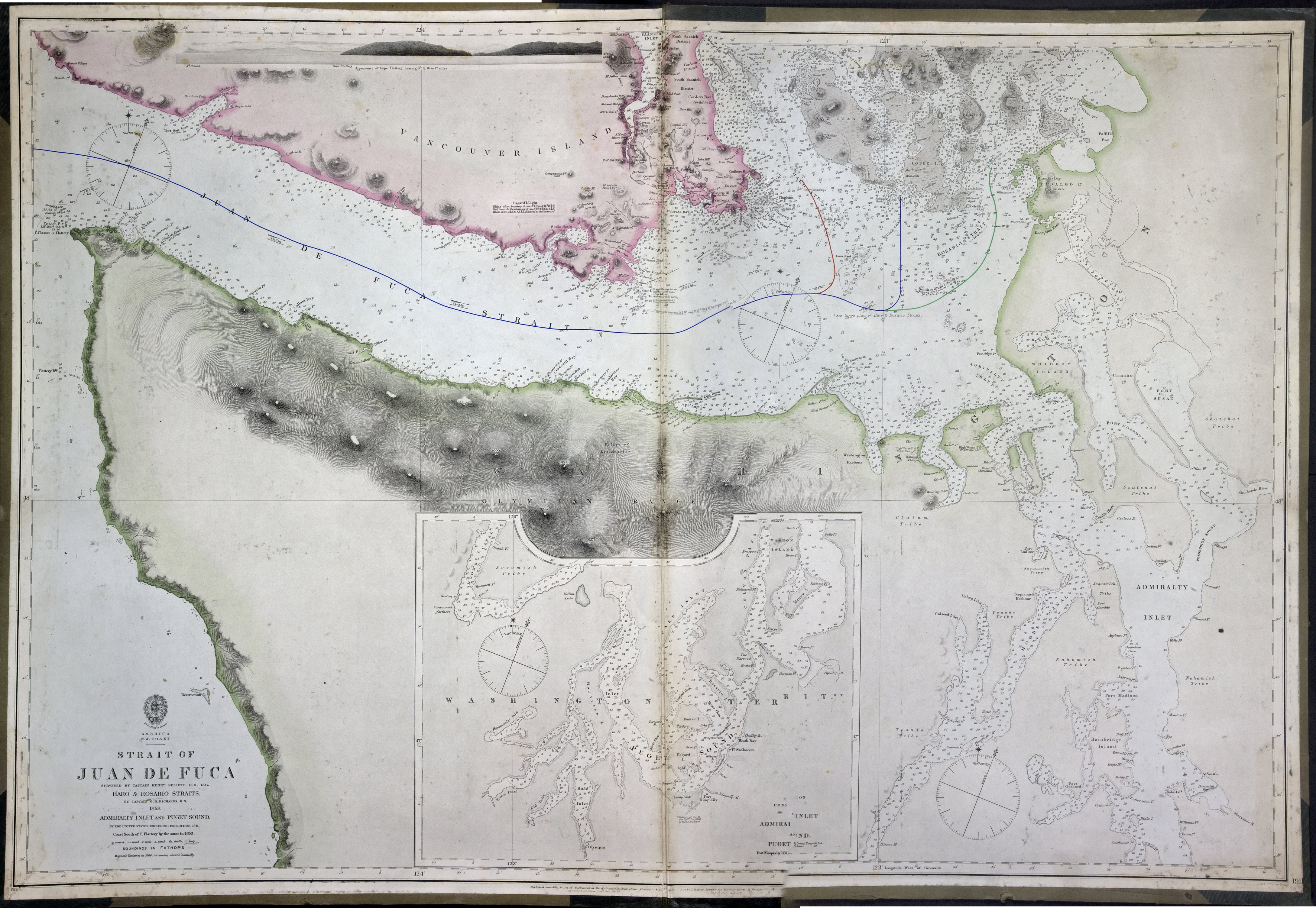
Title: Strait of Juan de Fuca surveyed by Captain Henry Kellett, R.N., 1847, Haro & Rosario Straits by Captain G.H. Richards, R.N. 1858, Admiralty Inlet and Puget Sound by the United States exploring expedition, 1841, coast south of Cape Flattery by the same in 1853.

Title: Strait of Juan de Fuca.

Author: Kellett, Henry, 1806-1875.

Subject: Juan de Fuca, Strait of (B.C. and Wash.) -- Maps; Nautical charts -- Juan de Fuca, Strait of (B.C. and Wash.); Puget Sound (Wash.) -- Maps; Nautical charts -- Puget Sound (Wash.); Nautical charts -- Haro Strait (B.C. and Wash.); Nautical charts -- Rosario Strait (Wash.); San Juan Boundary Dispute, 1846-1872.

Subject: Juan de Fuca, Strait, 1849, 1871

Identifier (repository): CO

Identifier (repoNumber): 700

Identifier (repoVol): canada

Identifier (libFileName): CO700-CANADA125 (8)

Identifier (penfoldNum): 514

Identifier (doc_id): CO700-CANADA125 (8)

Date: 1865

Funder: Funded by a Canadian Council of Archives, Archival Community Digitization Program.

Publisher: Great Britain. Hydrographic Office

Publisher: National Archives of the UK.

Identifier (CONTENTdm): oai:contentdm.library.uvic.ca:collection5/234

48 38'N-47 30'N/124 49'W-123 10'W.
Kellett, Henry, 1806-1875., Strait of Juan de Fuca surveyed by Captain Henry Kellett, R.N., 1847, Haro & Rosario Straits by Captain G.H. Richards, R.N. 1858, Admiralty Inlet and Puget Sound by the United States exploring expedition, 1841, coast south of Cape Flattery by the same in 1853, 1858-1865, Great Britain. Hydrographic Office, CO700-CANADA125 (8). The Colonial Despatches of Vancouver Island and British Columbia 1846-1871, Edition 2.4, ed. James Hendrickson and the Colonial Despatches project. Victoria, B.C.: University of Victoria. https://bcgenesis.uvic.ca/co_700-canada_125_8_1858_1865_j_d_f_s.html.
Last modified: 2022-12-15 13:24:22 -0800 (Thu, 15 Dec 2022) (SVN revision: 5648)