Maps accompanying the Report by Colonel D. R. Cameron, R.E., on the British-Alaska
Boundary. Author, Publisher, &c.: Official, London. [Nass, River, 1868; 1886]
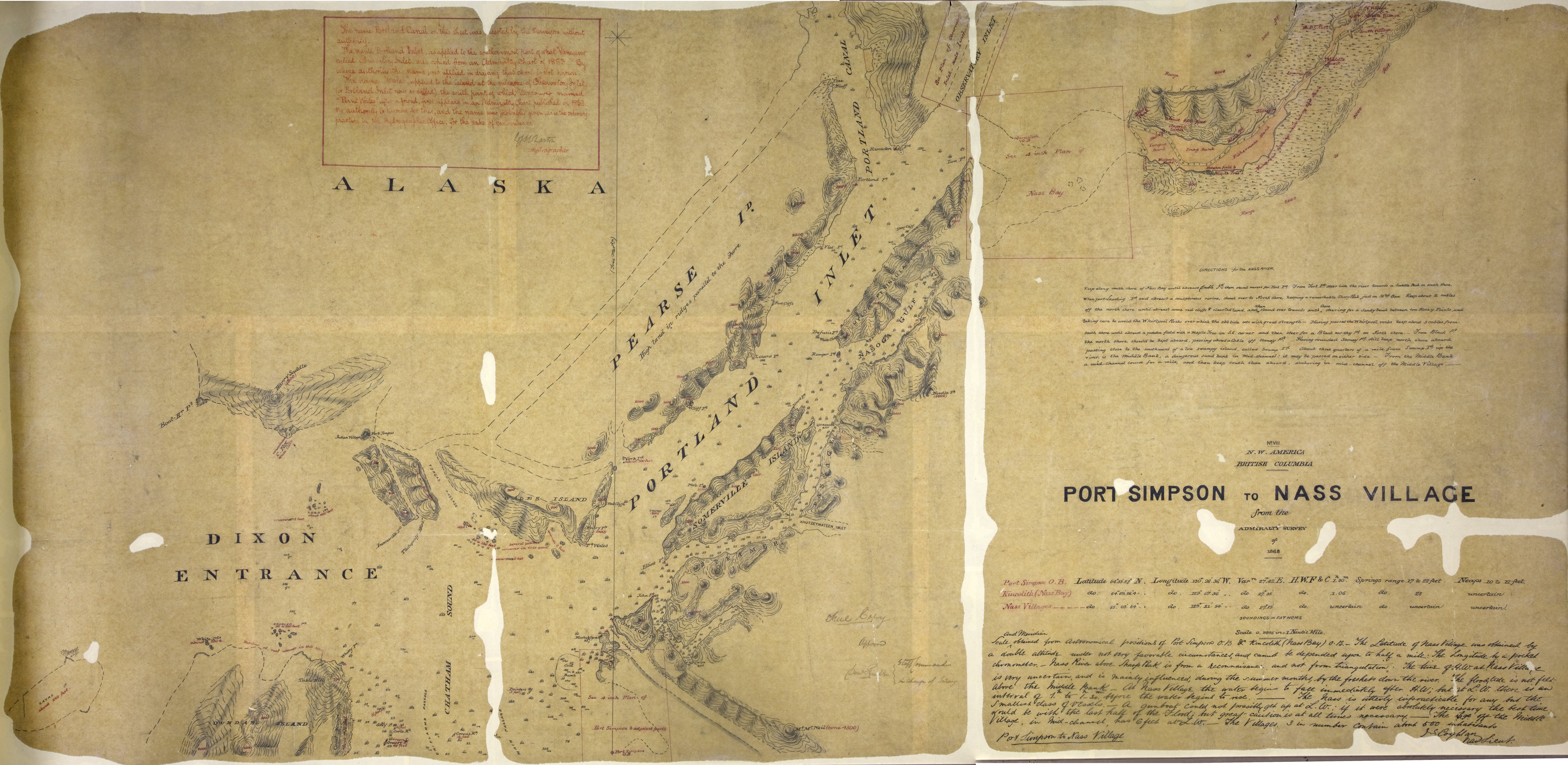
Includes Directions for the Nass River
The name Portland Canal on this sheet was inserted by the Surveyor withoht authority.
The name Portland Inlet, as applied to the southernmost of what Vancouver called Observatorh
Inlet, was clpied from an Admiralty Chart of 18/53. By whose authority the named was
applied in drawinfg that chart is not known. The name Wales
applied to the island at the entrance f Observatory Inlet, (or Portland Inlet now
so called) the south point of which Vancouver named Point Wales
after a friend, first appears in a\n Admiralty Chart published in 1853. No authority
is known for thus, and the name was probably given as is the ordinaryh practice in
the Hydrographic Office, for the sake of convenience. [signed] Hydrographer
Scale and meridian obtained from astronomical positions of Port Simpson O.B. & Kincolith
(Nass Bay) O.B. The latitude of Nass Village was obtained by a double altitude under
not very favorable circumstances, and can be depended upon to half a mile. The longitude
by a pocket chronometer. Nass River above Sharp Peak is from a reconnaisance and not
from triangulation. The time of H.W. at Nass Village is very uncertain and is mainly
influenced, during the summer months, by the freshets down the river. The floodtide
is not felt above the Middle Bank. At Nass Village the water begins to fall immediately
after H.W.; but at L.W. there is an interval of 1. h to 1.h 30. min. before the water
begins to rise. The Nass if utterly impracticable for any but the smallest class of
vessels. A gunboat could not possibly get up at L.W.: if it were absolutely necessary
the best time would be with the last half of the flood; but great caution is at all
times necessary. The [?] off the Middle Village, in mid-channel, has 6 feet at L.W.
The Villages, 3 in number contain about 600 inhabitants. [signed] Nav. Lieut.
Cameron, D. R. (Donald Roderick), 1834-1905,
Port Simpson to Nass Village, from the Admiralty survey of 1868, 1868, Great Britain. Colonial Office, CO700-CANADA144 (25).
The Colonial Despatches of Vancouver Island and British Columbia 1846-1871, Edition 2.6, ed. James Hendrickson and the Colonial Despatches project. Victoria,
B.C.: University of Victoria.
https://bcgenesis.uvic.ca/co_700-canada_144_25_1868_port_simpson_to_nass_village.html.
Title: Port Simpson to Nass Village, from the Admiralty survey of 1868
Title: N.W. America, British Columbia
Author: Cameron, D. R. (Donald Roderick), 1834-1905
Subject: British Columbia--Port Simpson--Maps; British Columbia--Nass River--Maps'
British Columbia--Kincolith--Maps; Alaska--Boundaries--Canada--Maps; Canada--Boundaries--Alaska--Maps
Subject: Nass, River, 1868, 1886
Identifier (repository): CO
Identifier (repoNumber): 700
Identifier (repoVol): canada
Identifier (libFileName): CO700-CANADA144 (25)
Identifier (penfoldNum): 535
Identifier (doc_id): CO700-CANADA144 (25)
Date: 1868
Funder: Funded by a Canadian Council of Archives, Archival Community Digitization
Program.
Publisher: Great Britain. Colonial Office
Publisher: National Archives of the UK.