Colonial Despatches
The colonial despatches of Vancouver Island and British Columbia 1846-1871
Haro and Rosario Straits
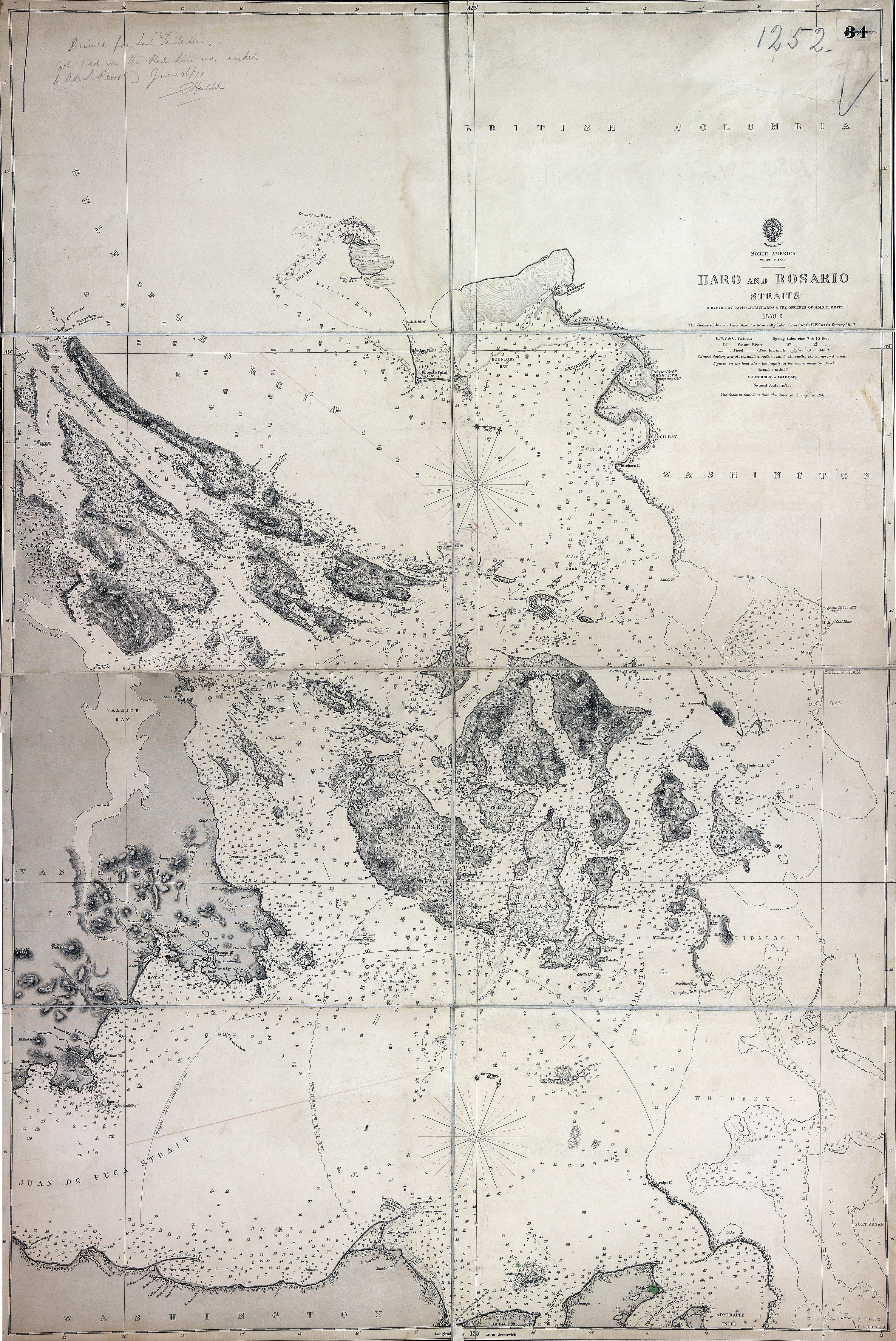
Haro and Rosario Straits, surveyed by Capt G.H. Richards and the officers of HMS Plumper,
with MS additions by Admiral Prevost, showing proposed boundary. Admiralty Chart 2689.
1:145,800. [Haro and Rosario Straits, 1859; 1871]. Soundings in fathoms. Relief shown
by spot heights and hachures.
Received from Lord Teuterdin, (who told me the Red Line was worked by Admiral Prevost
June 26/71 E. Harbild(?)
Richards, G.H. (George Henry), Haro and Rosario Straits, 1859, Great Britain. Hydrographic Office, FO 925/1252. The Colonial Despatches of Vancouver Island and British Columbia 1846-1871, Edition 2.6, ed. James Hendrickson and the Colonial Despatches project. Victoria,
B.C.: University of Victoria. https://bcgenesis.uvic.ca/fo_925-1252_haro_and_rosario_ss_1859.html.
Title: Haro and Rosario Straits
Author: Richards, G.H. (George Henry)
Subject: Haro Strait (B.C. and Wash.)--Maps; Rosario Strait (Wash.)--Maps
Subject: Haro and Rosario Straits, 1859, 1871
Identifier (repository): FO
Identifier (repoNumber): 925
Identifier (repoVol): 1252
Identifier (libFileName): FO925-1252
Identifier (penfoldNum): 494
Identifier (doc_id): FO 925/1252
Date: 1859
Funder: Funded by a Canadian Council of Archives, Archival Community Digitization Program.
Publisher: Great Britain. Hydrographic Office
Publisher: National Archives of the UK.
49 15'N--48 05'N / 123 35'W--122 25'W