Sketch map of part of the British possessions to the west of the Rocky Mountains.

Sketch map of part of the British possessions to the west of the Rocky Mountains.
North America. Sketch Map of part of the British Possessions to the West of the Rocky Mountains. Lithographed and printed at the Topographical Dept, War Department under the direction of Captain Elphinstone, RE; H James, Col RE, Superintendent. About 23 miles to 1 inch. Author, Publisher, &c.: War Office, London. [British Columbia, c. 1858]. Map includes reference key for food products, timber, animals, and fish. Descriptive text on farms, soil types, etc. Locates Forts and some First Nations villages and territories. MS text: Compiled from the best information.
Great Britain. Army. Royal Engineers. Columbia Detachment; Elphinstone, Howard Crawfurd, Sir, 1829-1890; James, H., 1803-1877., Sketch map of part of the British possessions to the west of the Rocky Mountains, 1858, Great Britain. War Office. Topographical Depot, FO 925/1381. The Colonial Despatches of Vancouver Island and British Columbia 1846-1871, Edition 2.4, ed. James Hendrickson and the Colonial Despatches project. Victoria, B.C.: University of Victoria. https://bcgenesis.uvic.ca/fo_925-1381_bc_1858_stitched_same_as_mpg_1-136.html.

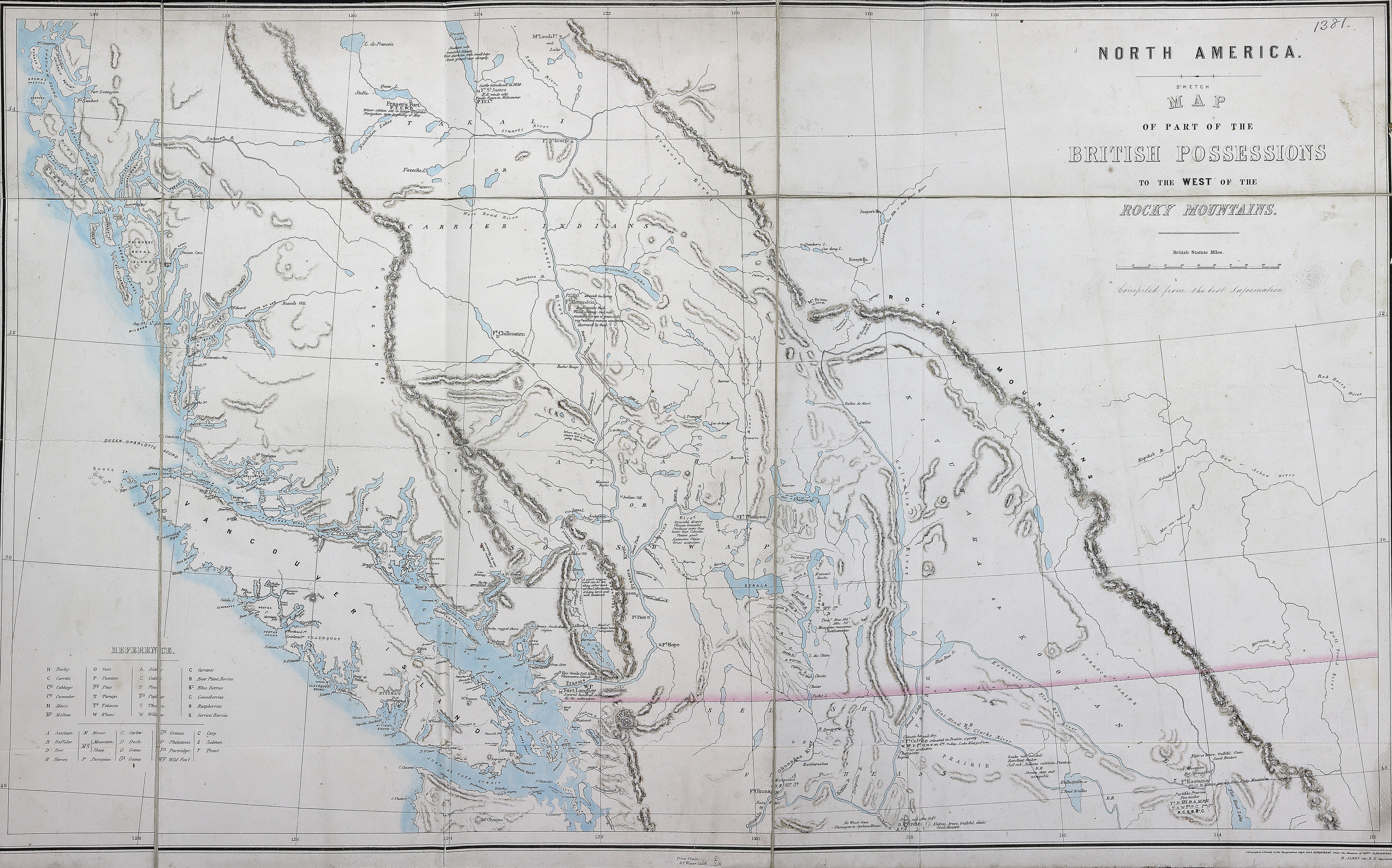
Title: Sketch map of part of the British possessions to the west of the Rocky Mountains.

Title: British Possessions to the West of the Rocky Mountains.

Author: Great Britain. Army. Royal Engineers. Columbia Detachment; Elphinstone, Howard Crawfurd, Sir, 1829-1890; James, H., 1803-1877.

Subject: British Columbia -- Maps; British Columbia -- History; British Columbia -- Agriculture; Indians of North America -- British Columbia.

Subject: British Columbia, 1858

Identifier (repository): FO

Identifier (repoNumber): 925

Identifier (repoVol): 1381

Identifier (libFileName): FO925-1381

Identifier (penfoldNum): 382

Identifier (doc_id): FO 925/1381

Date: 1858

Funder: Funded by a Canadian Council of Archives, Archival Community Digitization Program.

Publisher: Great Britain. War Office. Topographical Depot.

Publisher: National Archives of the UK.

Identifier (CONTENTdm): oai:contentdm.library.uvic.ca:collection5/152

48N-54N/128W-112W