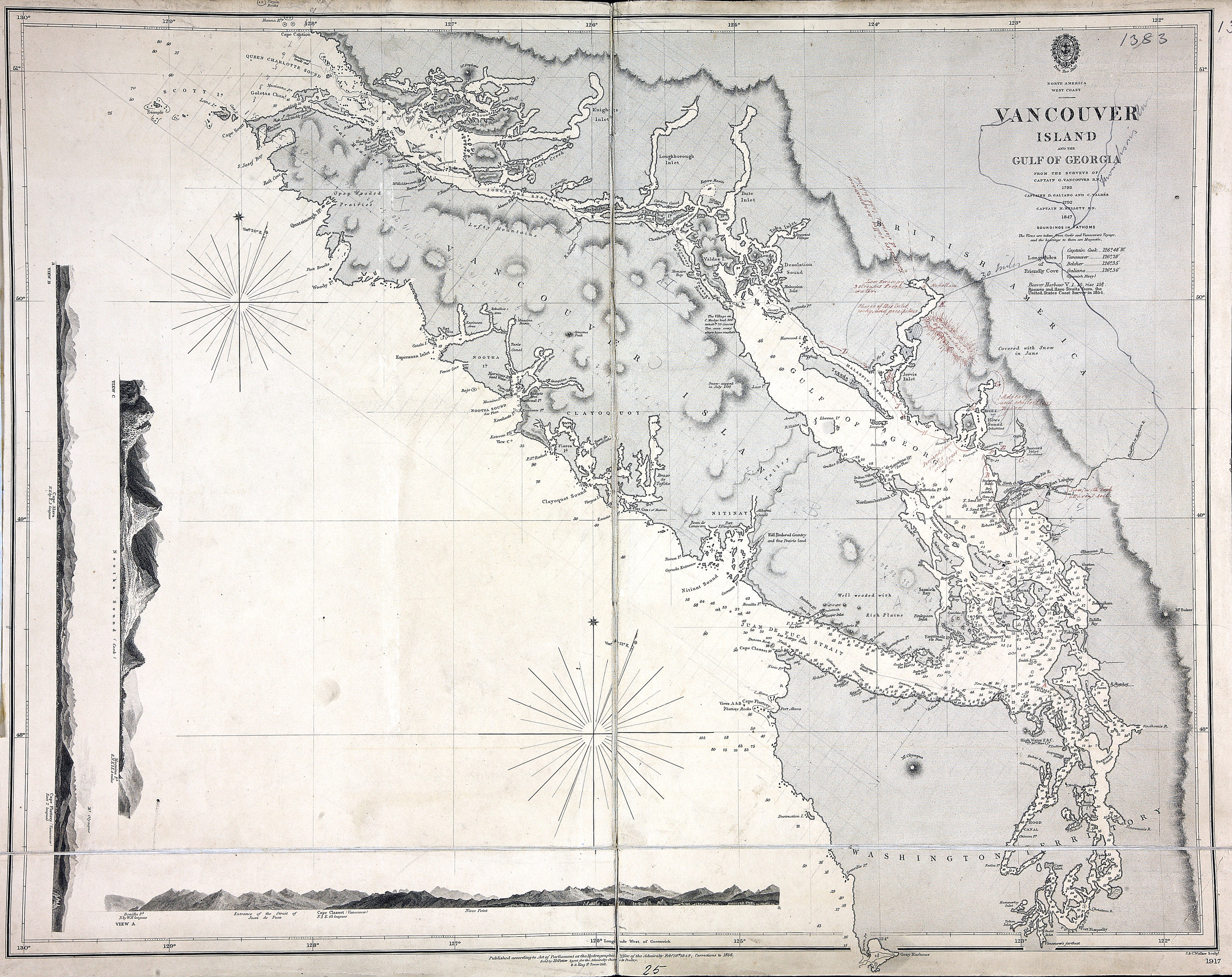
North America West Coast. Vancouver Island and the Gulf of Georgia : from the surveys
of Captain G. Vancouver R.N. 1793, Captains D. Galiano and C. Valdes 1792, Captain
H. Kellett R.N. 1847 ; Rosario and Haro Straits from the United States Coast Survey
1854. Hydrographic Office of the Admiralty, 1849, corrections to 1856; J. & C. Walker
sculpt. Admiralty map 1917. [Vancouver Island, 1849; 1856] Insets: Engraved views
from Cook's and Vancouver's Voyages. Relief shown by hachuring. Soundings in fathoms.
Shows First Nations villages; forts; Vancouver's track; anchorages. MS notes in red
describe terrain. Additional line extends Fraser and Thompson Rivers.
Vancouver, George, 1757-1798; Alcalá-Galiano, Dionisio, 1760-1805; Valdés Flores Bazán
y Peón, Cayetano, 1767-1835; Kellett, Henry, 1806-1875; Cook, James, 1728-1779; United
States Coast Survey; J. & C. Walker (Firm),
Vancouver Island and the Gulf of Georgia, 1849-1856, Great Britain. Hydrographic Office, FO 925/1383.
The Colonial Despatches of Vancouver Island and British Columbia 1846-1871, Edition 2.6, ed. James Hendrickson and the Colonial Despatches project. Victoria,
B.C.: University of Victoria.
https://bcgenesis.uvic.ca/fo_925-1383_van_isl_1849_1856.html.
Title: Vancouver Island and the Gulf of Georgia.
Title: Vancouver Island and the Strait of Georgia.
Author: Vancouver, George, 1757-1798; Alcalá-Galiano, Dionisio, 1760-1805; Valdés
Flores Bazán y Peón, Cayetano, 1767-1835; Kellett, Henry, 1806-1875; Cook, James,
1728-1779; United States Coast Survey; J. & C. Walker (Firm)
Subject: Vancouver Island (B.C.) -- Maps; Georgia, Strait of (B.C. and Wash.) -- Maps;
Rosario Strait (Wash.) -- Maps; Haro Strait (B. C. and Wash.) -- Maps; Nautical charts
-- British Columbia; Indians of North America -- British Columbia.
Subject: Vancouver Island, 1849, 1856
Identifier (repository): FO
Identifier (repoNumber): 925
Identifier (repoVol): 1383
Identifier (libFileName): FO925-1383
Identifier (penfoldNum): 563
Identifier (doc_id): FO 925/1383
Date: 1856
Funder: Funded by a Canadian Council of Archives, Archival Community Digitization
Program.
Publisher: Great Britain. Hydrographic Office
Publisher: National Archives of the UK.
View in UVic Libraries Vault repository
51N-47 10'N/130W-122W
