Reconnaissance of Canal de Haro and Strait of Rosario, and approaches.

Reconnaissance of Canal de Haro and Strait of Rosario, and approaches.
United States Coast Survey chart: 'Reconnaissance of Canal de Haro & Strait of Rosario and approaches. Geographical Positions & Triangulation by G. Davidson Assist. Hydrography by the Party under the command of Lieut. J. Alden, U.S.N. Assist…. 1854'. Notes on sources; table of abbreviations. Compass rose. Insets: Admiralty Inlet and Puget Sound (1:600, 000). Reduced drawing by A Boschke, J J Ricketts and F Boucher. Engraved by R T Knight and R F Bartle. Printed by Wagner and McGuigan. Verified by H W Benham, Capt of Engineers, Assistant, US Coast Survey Office (A.D. Bache, Superintendent).
In C Wood of 2 Oct 1856. US Coast Survey. [Haro and Rosario Straits, 1854]
United States Coast Survey, Reconnaissance of Canal de Haro and Strait of Rosario, and approaches, 1854, United States Coast Survey, FO 925/1395. The Colonial Despatches of Vancouver Island and British Columbia 1846-1871, Edition 2.4, ed. James Hendrickson and the Colonial Despatches project. Victoria, B.C.: University of Victoria. https://bcgenesis.uvic.ca/fo_925-1395_haro_and_rosario_ss_1854.html.

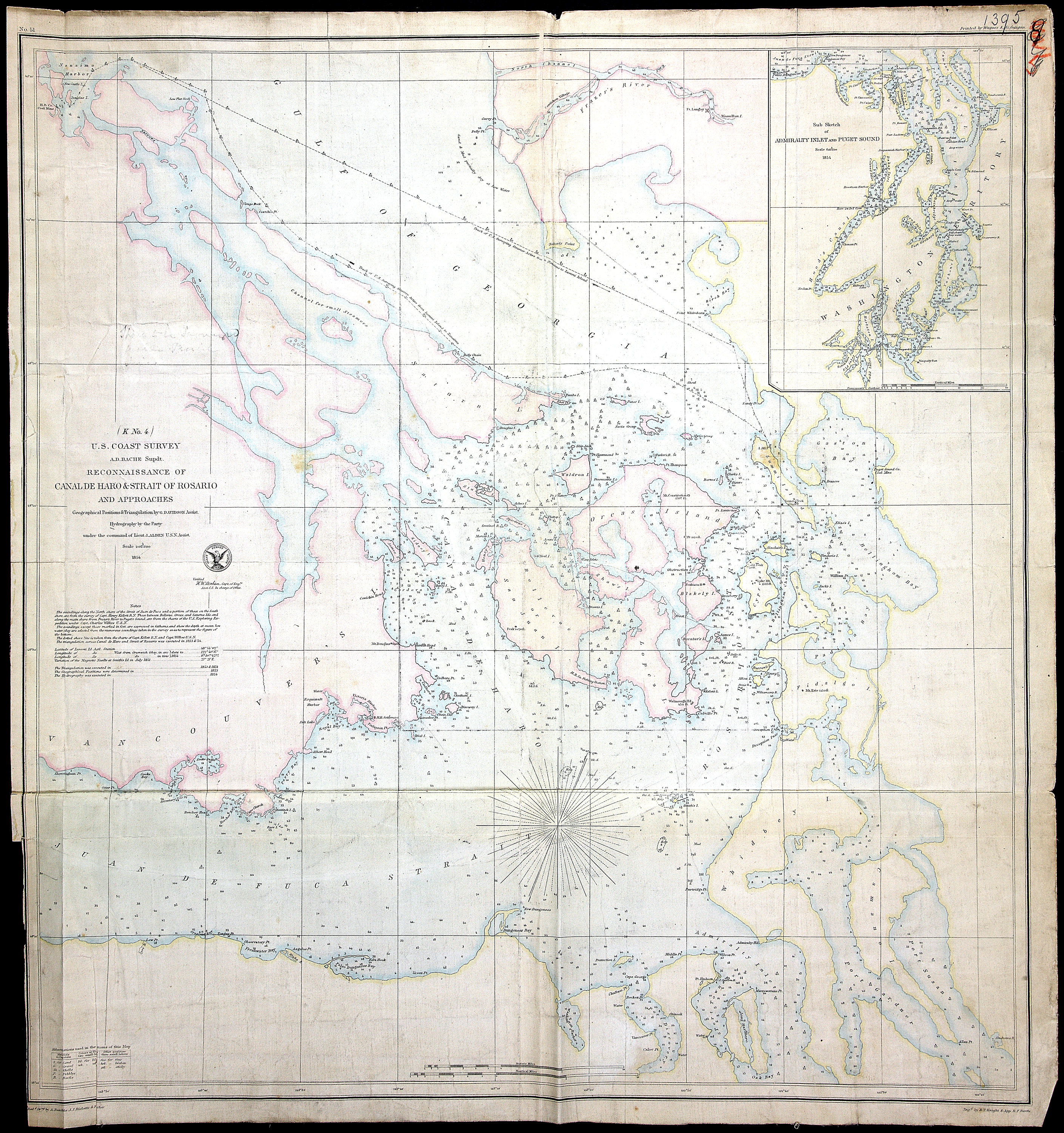
Title: Reconnaissance of Canal de Haro and Strait of Rosario, and approaches.

Author: United States Coast Survey

Subject: Haro Strait (B.C. and Wash.) -- Maps; Rosario Strait (Wash.) -- Maps; Georgia, Strait of (B.C. and Wash.) -- Maps; Juan de Fuca Strait (B.C. and Wash.) -- Maps; Puget sound (Wash.) -- Maps; Nautical charts -- Georgia, Strait of (B.C. and Wash.); Nautical charts -- Washington (State) -- Puget Sound; Nautical charts -- Juan de Fuca Strait (B.C. and Wash.).

Subject: Haro and Rosario Straits, 1854

Identifier (repository): FO

Identifier (repoNumber): 925

Identifier (repoVol): 1395

Identifier (libFileName): FO925-1395

Identifier (penfoldNum): 481

Identifier (doc_id): FO 925/1395

Date: 1854

Funder: Funded by a Canadian Council of Archives, Archival Community Digitization Program.

Publisher: United States Coast Survey

Publisher: National Archives of the UK.

Identifier (CONTENTdm): oai:contentdm.library.uvic.ca:collection5/53

49 10'N-48 10'N/123 50'W-122 20'W