Colonial Despatches
The colonial despatches of Vancouver Island and British Columbia 1846-1871
Vancouver Island and adjacent shores of British Columbia.
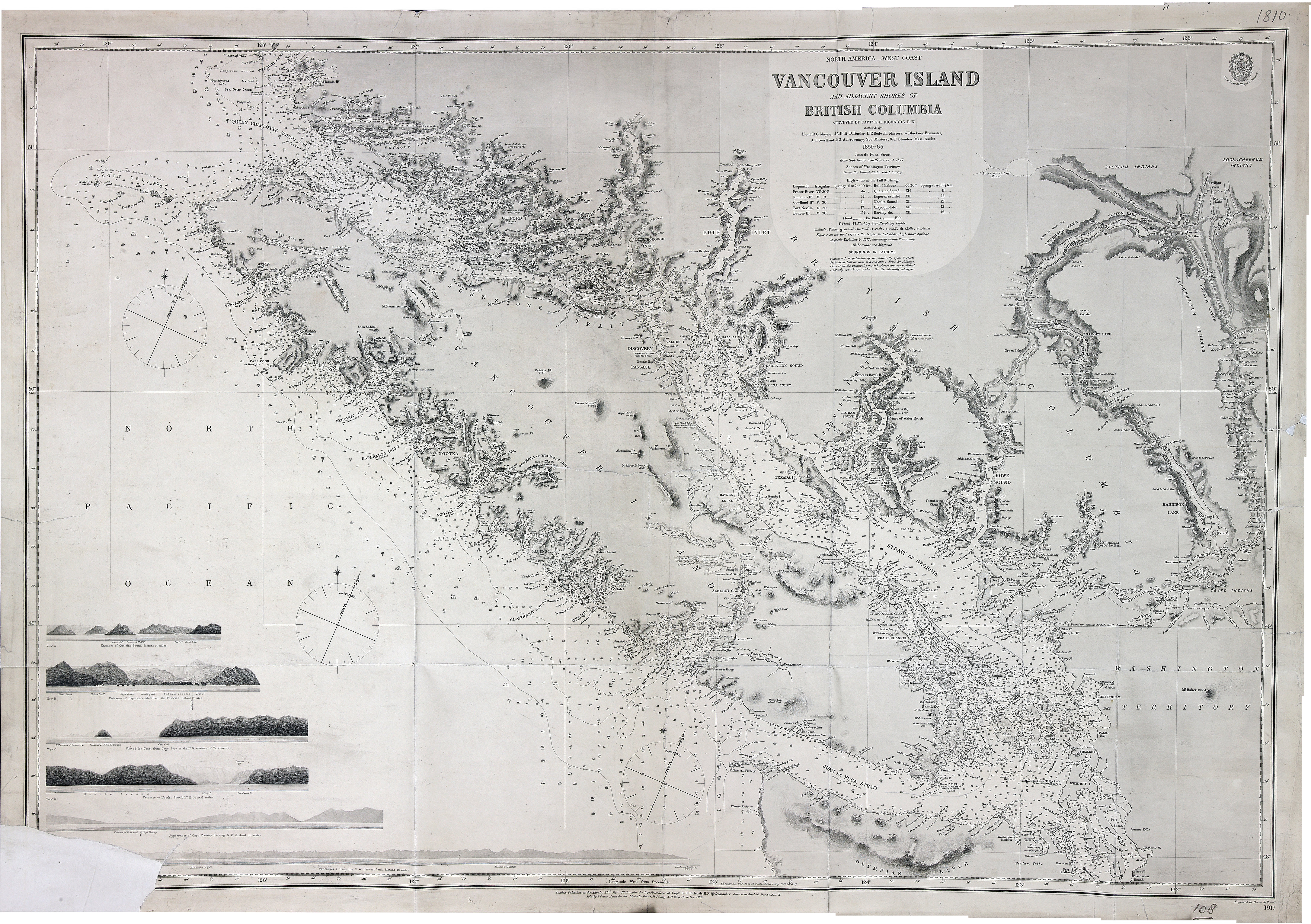
Vancouver Island and adjacent shores of British Columbia; surveyed by Captn. G.H.
Richards, R.N. assisted by Lieut. R.C. Mayne ; J.A. Bull, D. Pender, E.P. Bedwell,
Masters ; J.T. Gowlland & G.A. Browning, Sec. Masters, & E. Blunden, Mast. Assist.
1859-64 ; Juan de Fuca Strait from Capt. Henry Kellett's survey of 1847, shores of
Washington Territory from the United States Coast survey ; [compiled & drawn for engraving
by E.J. Powell of the Hydrographic Office] ; engraved by Davies & Powell. Admiralty
Chart 1917. About 10 miles to one inch. Admiralty. [Vancouver Island, 1859-65; 1871].
Lower left corner damaged. At head of title: North America, west coast. Relief shown
by bathymetry, soundings in feet, hachures and spot heights. Includes nautical features.
Shows First Nations territories. Side views of several features bottom left. First
published 1865, updated and corrected. Latest date on map 1871?.
Richards, G. H. (George Henry), Vancouver Island and adjacent shores of British Columbia, 1859-1865, Great Britain. Hydrographic Office, FO925-1810. The Colonial Despatches of Vancouver Island and British Columbia 1846-1871, Edition 2.6, ed. James Hendrickson and the Colonial Despatches project. Victoria,
B.C.: University of Victoria. https://bcgenesis.uvic.ca/fo_925-1810_van_isl_1859_65_1865.html.
Title: Vancouver Island and adjacent shores of British Columbia.
Author: Richards, G. H. (George Henry)
Subject: Vancouver Island (B.C.) -- Maps; British Columbia -- Coasts -- Maps; Nautical charts -- British Columbia; Nautical charts -- Juan de Fuca Strait (B.C. and Wash.).
Subject: Vancouver Island, 1859-65, 1871
Identifier (repository): FO
Identifier (repoNumber): 925
Identifier (repoVol): 1810
Identifier (libFileName): FO925-1810
Identifier (penfoldNum): 570
Identifier (doc_id): FO925-1810
Date: 1865
Funder: Funded by a Canadian Council of Archives, Archival Community Digitization Program.
Publisher: Great Britain. Hydrographic Office
Publisher: National Archives of the UK.
51 24'N-47 54'N/130 27'W-121 32'W.