Reduced map of a portion of British Columbia, compiled from the surveys and explorations of the Royal Navy and Royal Engineers at the camp New Westminster, 24 Nov 1859.

Reduced map of a portion of British Columbia, compiled from the surveys and explorations of the Royal Navy and Royal Engineers at the camp New Westminster, 24 Nov 1859.
Reduced map of a portion of British Columbia, compiled from the surveys and explorations of the Royal Navy and Royal Engineers at the camp New Westminster, 24 Nov 1859. Illustrating the route persued by Governor Douglas in late tour in British Columbia (boundary line of 1846 given). 16 miles to one inch. J. Arrowsmith, London. Lithographed. [British Columbia, Washington, 1861]
Arrowsmith, John, 1790-1873., Reduced map of a portion of British Columbia, compiled from the surveys and explorations of the Royal Navy and Royal Engineers at the camp New Westminster, 24 Nov 1859, 1859-1861, John Arrowsmith, FO 925/1822. The Colonial Despatches of Vancouver Island and British Columbia 1846-1871, Edition 2.4, ed. James Hendrickson and the Colonial Despatches project. Victoria, B.C.: University of Victoria. https://bcgenesis.uvic.ca/fo_925-1822_bc_1861_1859.html.

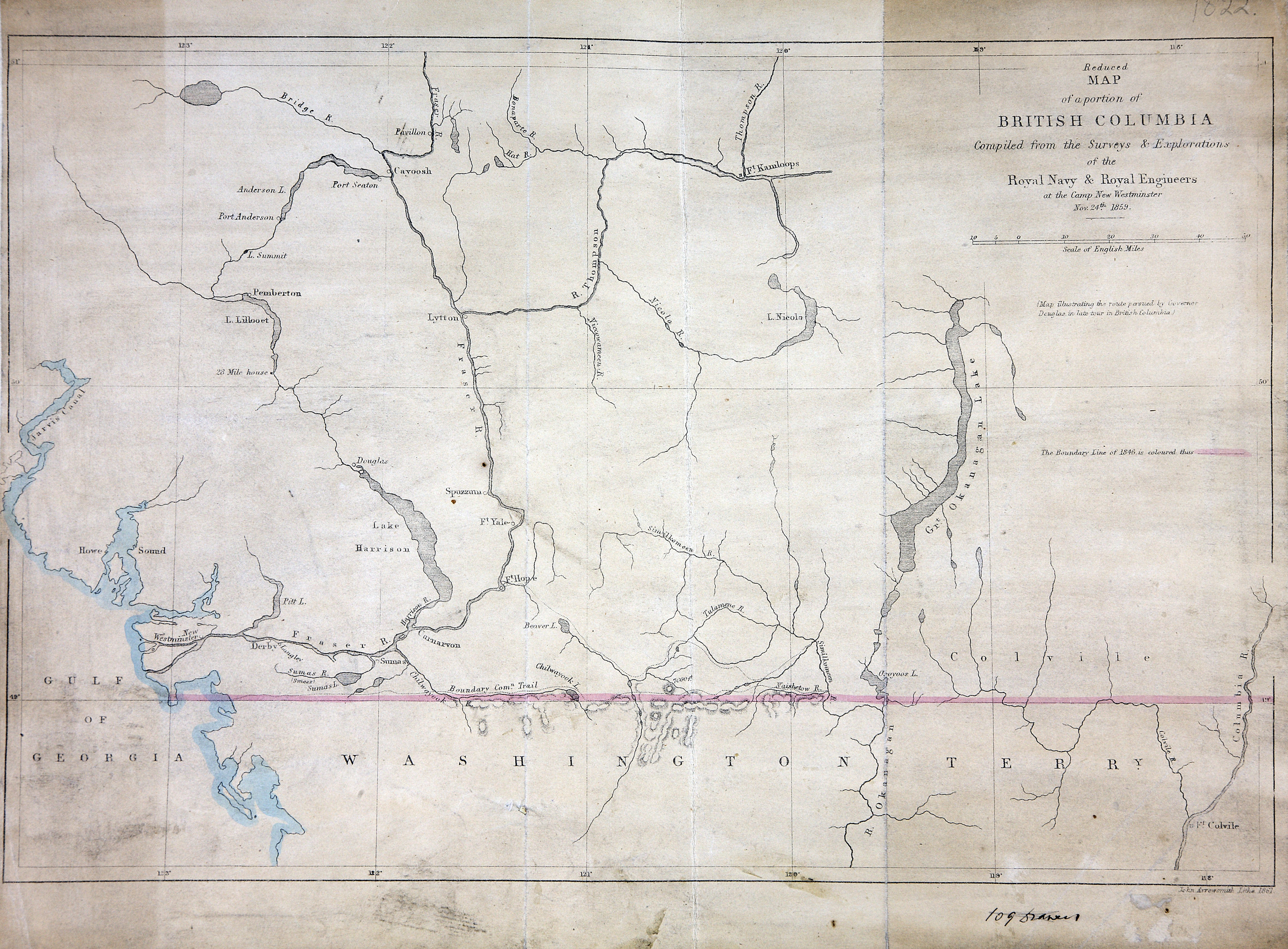
Title: Reduced map of a portion of British Columbia, compiled from the surveys and explorations of the Royal Navy and Royal Engineers at the camp New Westminster, 24 Nov 1859.

Author: Arrowsmith, John, 1790-1873.

Subject: British Columbia -- Maps; Washington (State) -- Maps; Douglas, James, Sir, 1803-1877 -- Travel.

Subject: British Columbia, Washington, 1861

Identifier (repository): FO

Identifier (repoNumber): 925

Identifier (repoVol): 1822

Identifier (libFileName): FO925-1822

Identifier (penfoldNum): 400

Identifier (doc_id): FO 925/1822

Date: 1859

Funder: Funded by a Canadian Council of Archives, Archival Community Digitization Program.

Publisher: John Arrowsmith.

Publisher: National Archives of the UK.

Identifier (CONTENTdm): oai:contentdm.library.uvic.ca:collection5/251

51N-49N/123W-118W
Arrowsmith, John, 1790-1873., Reduced map of a portion of British Columbia, compiled from the surveys and explorations of the Royal Navy and Royal Engineers at the camp New Westminster, 24 Nov 1859, 1859-1861, John Arrowsmith, FO 925/1822. The Colonial Despatches of Vancouver Island and British Columbia 1846-1871, Edition 2.4, ed. James Hendrickson and the Colonial Despatches project. Victoria, B.C.: University of Victoria. https://bcgenesis.uvic.ca/fo_925-1822_bc_1861_1859.html.
Last modified: 2022-12-15 13:24:22 -0800 (Thu, 15 Dec 2022) (SVN revision: 5648)