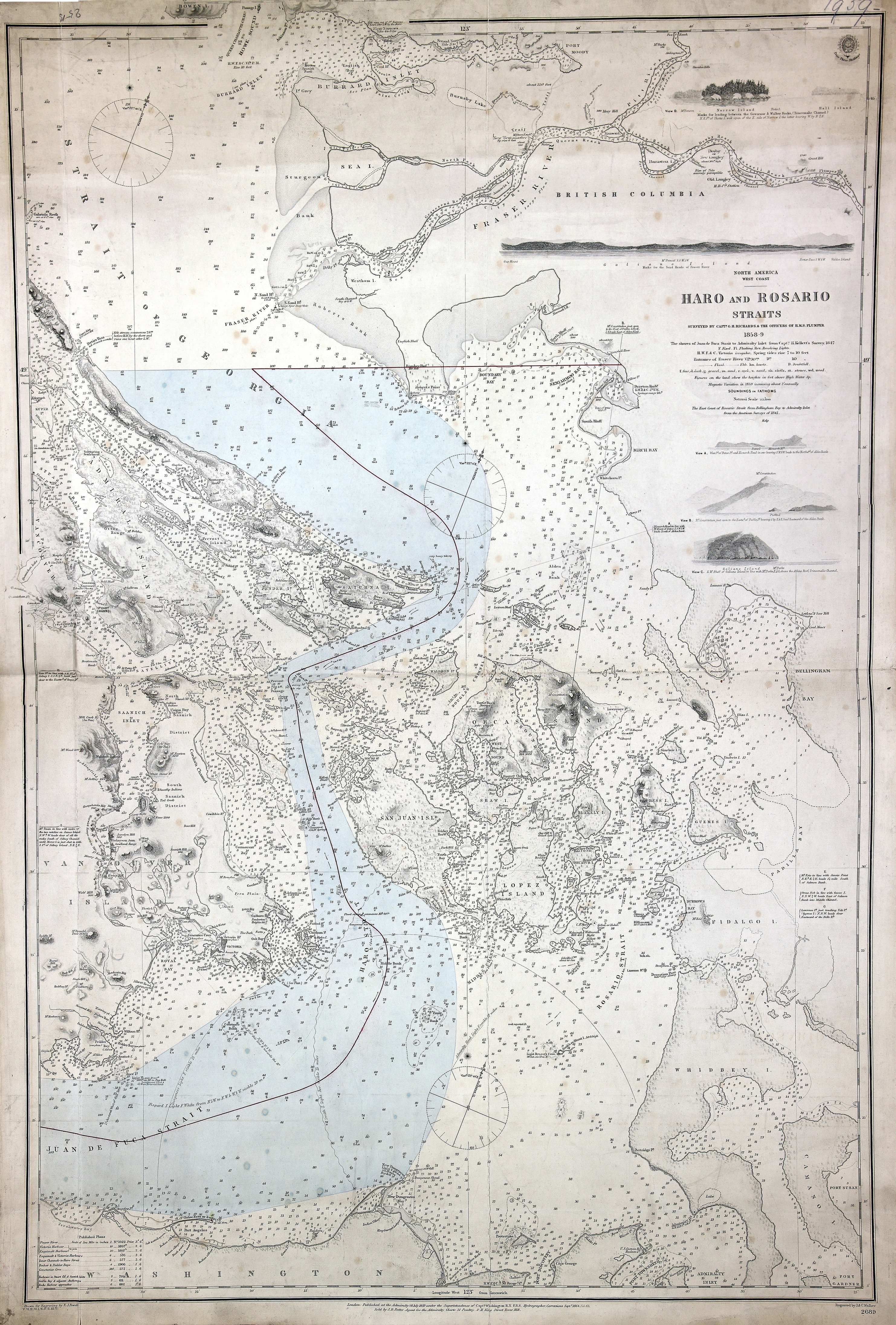
San Juan Boundary. Charts showing Admiralty Hydrographers opinion respecting the line
of boundary as constituted by the award of the German Emperor, 21 Oct 1872. Admiralty
Charts 1191 and 2689. 2.5 sea miles to one inch. Enclosed in Admiralty letter of 14
Nov 1872. Admiralty. [Haro and Rosario Straits, 1859; 1871; 1872].
At head of title: North America, west coast. Surveyed by Captn. G.H. Richards, & the
Officers of H.M.S. Plumper 1858-9. Drawn for engraving by E.J. Powell. Engraved by
J. & C. Walker. The shores of Juan de Fuca Strait to Admiralty Inlet from Captn. H.
Kellett's survey, 1847. The east coast of Rosario Strait from Bellingham Bay to Admiralty
Inlet taken from the American surveys of 1841. First published 1859 updated and corrected.
Latest date on map 1871. Relief shown by hachures and spot heights; depths shown by
soundings in fathoms. Includes side views of various landmarks.
Richards, G. H. (George Henry),
Haro and Rosario Straits, 1859-1865, Great Britain. Hydrographic Service., FO 925/1959.
The Colonial Despatches of Vancouver Island and British Columbia 1846-1871, Edition 2.6, ed. James Hendrickson and the Colonial Despatches project. Victoria,
B.C.: University of Victoria.
https://bcgenesis.uvic.ca/fo_925-1959_pt1_haro_and_rosario_ss_1859_1865.html.
Title: Haro and Rosario Straits.
Title: North America, west coast, Haro and Rosario Straits.
Author: Richards, G. H. (George Henry)
Subject: Nautical charts -- Haro Strait (B.C. and Wash.); Nautical charts -- British
Columbia -- Gulf Islands; Nautical charts -- Washington (State) -- Rosario Strait;
Nautical charts -- Washington (State) -- San Juan Islands; San Juan Boundary Dispute,
1846-1872.
Subject: Haro and Rosario Straits, 1859, 1871, 1872
Identifier (repository): FO
Identifier (repoNumber): 925
Identifier (repoVol): 1959
Identifier (libFileName): FO925-1959 pt2
Identifier (penfoldNum): 519
Identifier (doc_id): FO 925/1959
Date: 1859
Funder: Funded by a Canadian Council of Archives, Archival Community Digitization
Program.
Publisher: Great Britain. Hydrographic Service.
Publisher: National Archives of the UK.
View in UVic Libraries Vault repository
49 19'N-N 48 5'/ 123 39'W-122 25'W.