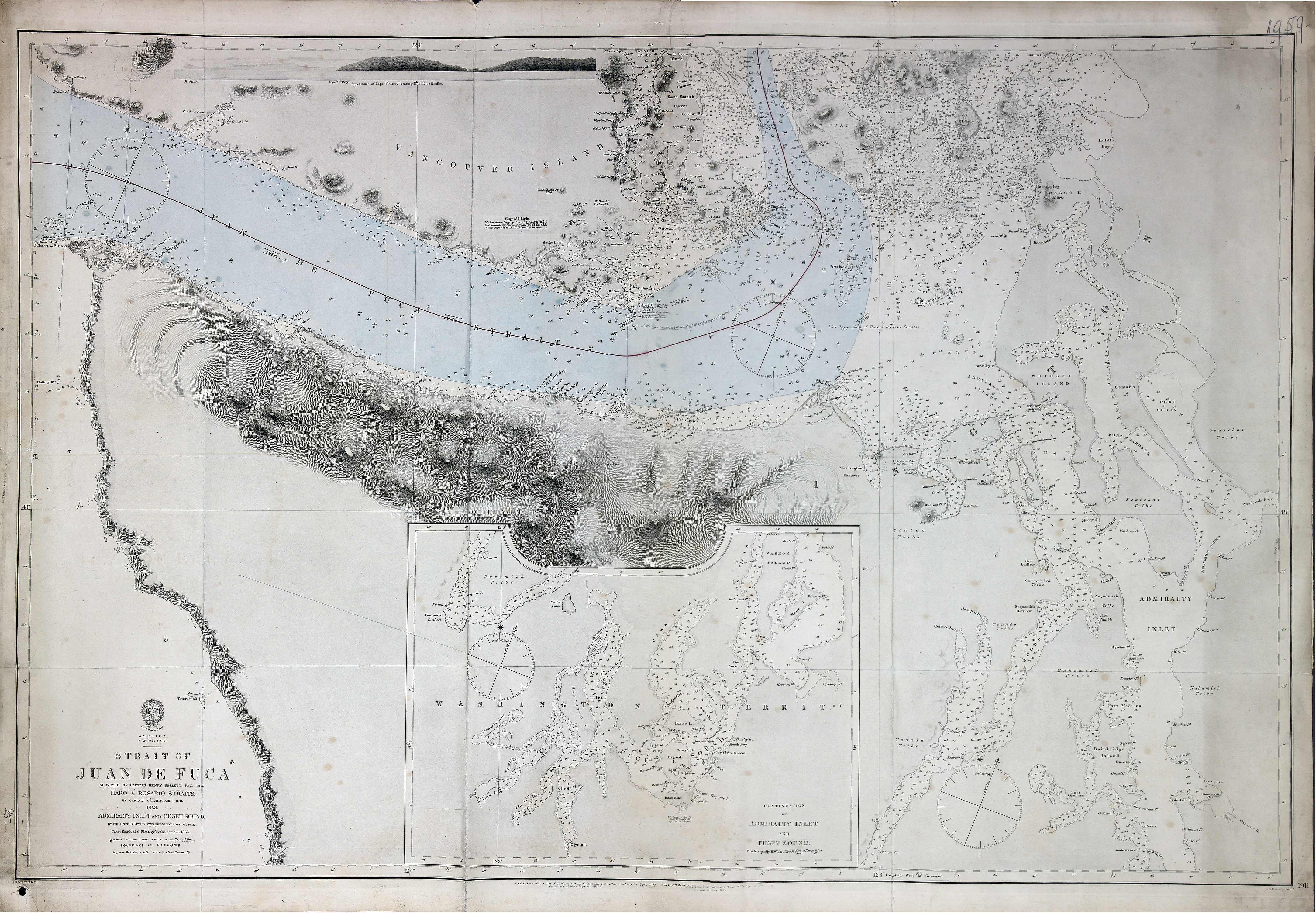
San Juan Boundary. Charts showing Admiralty Hydrographers opinion respecting the line
of boundary as constituted by the award of the German Emperor, 21 Oct 1872. Admiralty
Charts 1191 and 2689. 2.5 sea miles to one inch. Enclosed in Admiralty letter of 14
Nov 1872. Admiralty. [Juan de Fuca, Strait, 1849; 1871; 1872].
At head of title: America, N.W. Coast. surveyed by Captain Henry Kellett, R.N. 1847,
Haro & Rosario straits, by Captain G. H. Richards, R.N. 1858, Admiralty inlet and
Puget sound, by the United States Exploring Expedition, 1841, coast south of C. Flattery
by the same in 1853 ; J. & C. Walker sculpt. Published Jany. 18th. 1849; Corrections
& additions Augst. 1864, Feb. 65; small corrections: Jan., April, Dec. 1871; Nov.
1872. Soundings in fathoms. Insets: Continuation of Admiralty inlet and Puget sound;
side view title: Appearance of Cape Flattery bearing N.E. 16 or 17 miles. Relief shown
by hachures and spot heights; depths shown by soundings in fathoms.
Kellett, Henry, 1806-1875.,
Strait of Juan de Fuca, 1858, Great Britain. Hydrographic Office, FO 925/1959.
The Colonial Despatches of Vancouver Island and British Columbia 1846-1871, Edition 2.6, ed. James Hendrickson and the Colonial Despatches project. Victoria,
B.C.: University of Victoria.
https://bcgenesis.uvic.ca/fo_925-1959_pt2_j_d_f_s_1858.html.
Title: Strait of Juan de Fuca
Author: Kellett, Henry, 1806-1875.
Subject: Juan de Fuca, Strait of (B.C. and Wash.) -- Maps; Nautical charts -- Juan
de Fuca, Strait of (B.C. and Wash.); Puget Sound (Wash.) -- Maps; Nautical charts
-- Puget Sound (Wash.); Nautical charts -- Haro Strait (B.C. and Wash.); Nautical
charts -- Rosario Strait (Wash.); Flattery, Cape (Wash.); San Juan Boundary Dispute,
1846-1872.
Subject: Juan de Fuca, Strait, 1849, 1871, 1872
Identifier (repository): FO
Identifier (repoNumber): 925
Identifier (repoVol): 1959
Identifier (libFileName): FO925-1959 pt2
Identifier (penfoldNum): 519
Identifier (doc_id): FO 925/1959
Date: 1858
Funder: Funded by a Canadian Council of Archives, Archival Community Digitization
Program.
Publisher: Great Britain. Hydrographic Office
Publisher: National Archives of the UK.
View in UVic Libraries Vault repository
48 35'N--47 30'N / 124 45'W--122 10'W