Colonial Despatches
The colonial despatches of Vancouver Island and British Columbia 1846-1871
Tracing from Admiralty chart 1897(a) showing Plumper Bay, Thetis Cove, Esquimalt, Vancouver Island.
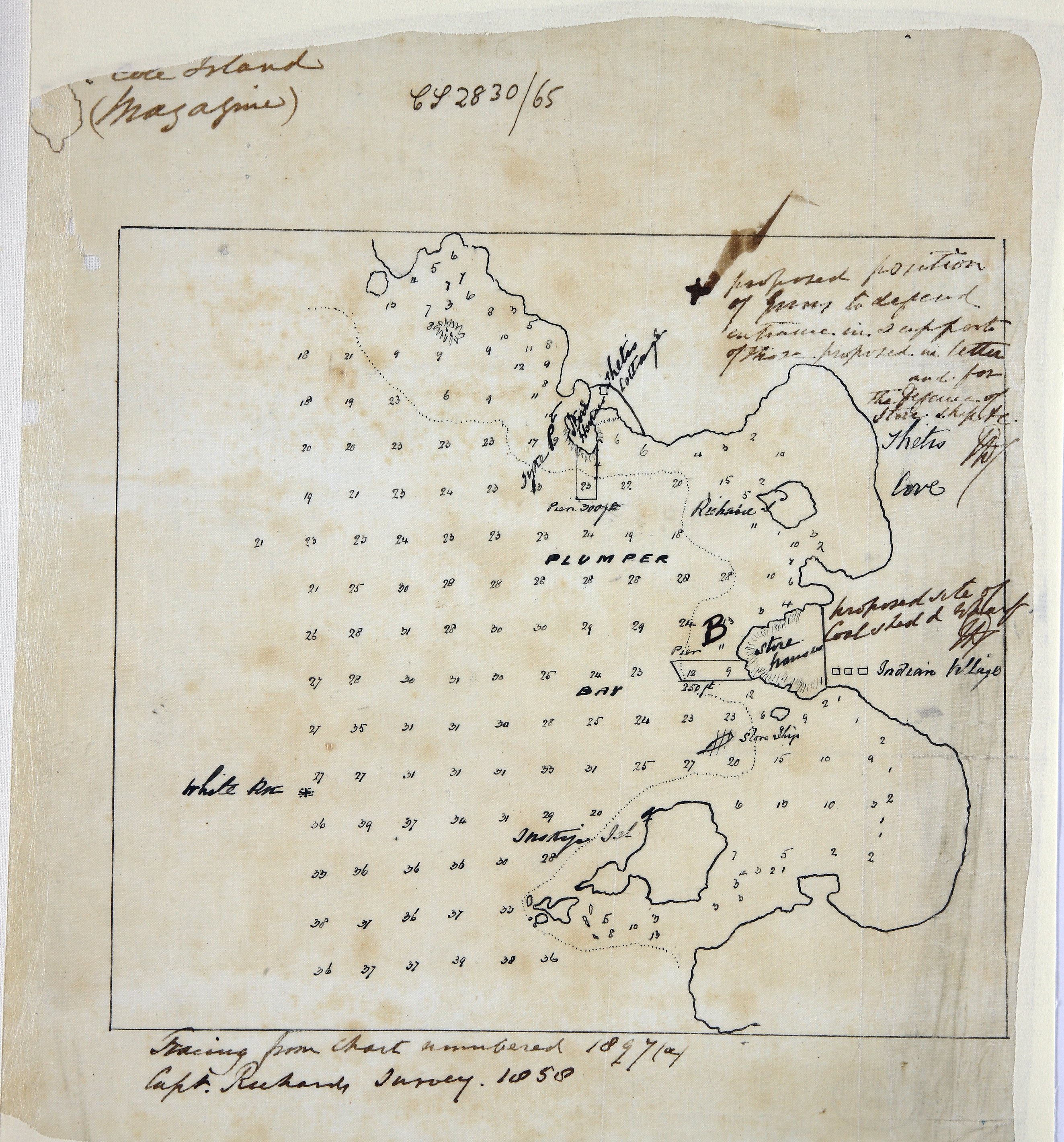
Tracing from Admiralty chart 1897(a) showing Plumper Bay, Thetis Cove, Esquimalt,
Vancouver Island (now in British Columbia, Canada) showing soundings, the proposed
site of the coal shed and wharf and the proposed positions of guns. Shows First nations
village. Scale: 1 inch to 680 feet (calculated). Originally accompanying a letter,
dated 18 August 1865 from Trevenor P Coole, Captain, and William H Sharp, Master,
HMS Sutlej to the Honourable Joseph Denman, Rear Admiral, Commander in Chief, Pacific
Squadron, enclosed in the Rear Admiral's letter number 106 dated 18 August 1865. From
Capt. Richards's survey 1858.
Richards, G. H. (George Henry), Tracing from Admiralty chart 1897(a) showing Plumper Bay, Thetis Cove, Esquimalt,
Vancouver Island, 1858, National Archives of the UK, MFQ 1/632/4. The Colonial Despatches of Vancouver Island and British Columbia 1846-1871, Edition 2.6, ed. James Hendrickson and the Colonial Despatches project. Victoria,
B.C.: University of Victoria. https://bcgenesis.uvic.ca/mfq_1-632_4_plumper_bay_1858.html.
Title: Tracing from Admiralty chart 1897(a) showing Plumper Bay, Thetis Cove, Esquimalt, Vancouver Island.
Title: Plumper Bay, Thetis Cove, Esquimalt, Vancouver Island.
Author: Richards, G. H. (George Henry)
Subject: Nautical charts -- British Columbia -- Plumper Bay; Plumper Bay (B.C.) -- Maps; Thetis Cove (B.C.) -- Maps; Esquimalt (B.C.) -- Maps.
Identifier (repository): MFQ
Identifier (repoNumber): 1
Identifier (repoVol): 632
Identifier (libFileName): MFQ1-632 (4)
Identifier (penfoldNum):
Identifier (doc_id): MFQ 1/632/4
Date: 1858
Funder: Funded by a Canadian Council of Archives, Archival Community Digitization Program.
Publisher: National Archives of the UK.