Colonial Despatches
The colonial despatches of Vancouver Island and British Columbia 1846-1871
Port Simpson, 1853.
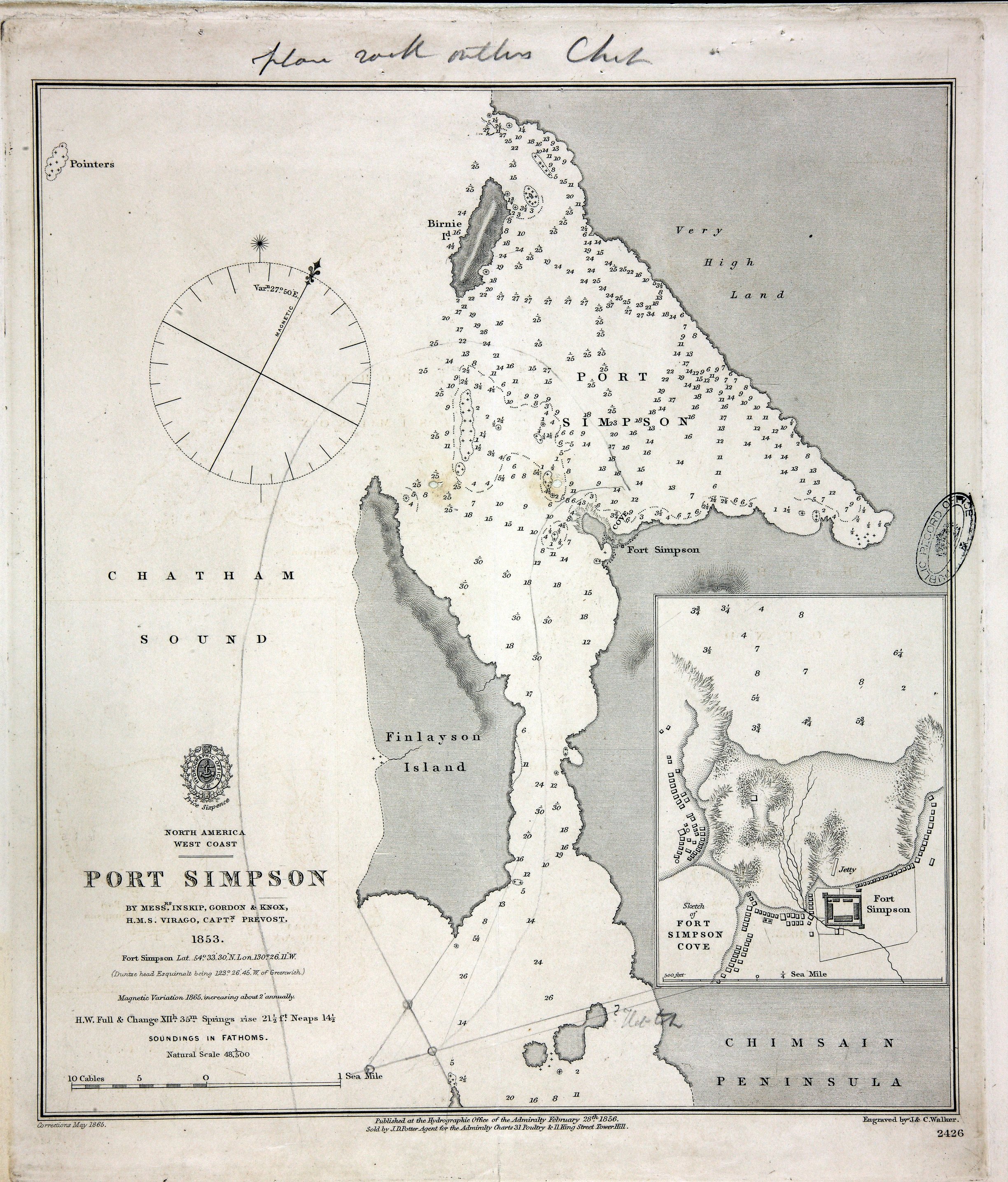
North America West Coast. Port Simpson by Messrs. Inskip, Gordon & Knox, HMS Virago,
Capt. Prevost. 1853. Published at the Hydrographic Office of the Admiralty 28 February
1856. Correction to May 1865. Soundings in fathoms. An inset shows a sketch of Fort
Simpson Cove with location of Fort and other buildings. Scale: 1 inch to 480 feet.
Compass rose. Engraved by J and C Walker. Admiralty chart of Port Simpson (now Lax
Kw'alaams), British Columbia, showing Birnie and Finlayson Islands and [Chimsair]
Peninsula. Originally enclosed with a memorandum dated 13 August 1866 by George Henry
Richards, Hydrographer of the Admiralty, concerning the grounding of HMS Sparrowhawk.
MS lines on the chart link certain points south of Finlayson Island, one labelled
'? North'. An MS note reads 'plan with outline Chart'.
Inskip (Master HMS Virago)., Port Simpson, 1853, 1853-1856, Great Britain. Hydrographic Office, MFQ 1/632/5. The Colonial Despatches of Vancouver Island and British Columbia 1846-1871, Edition 2.6, ed. James Hendrickson and the Colonial Despatches project. Victoria,
B.C.: University of Victoria. https://bcgenesis.uvic.ca/mfq_1-632_5_port_simpson_1853_1856.html.
Title: Port Simpson, 1853.
Author: Inskip (Master HMS Virago).
Subject: Port Simpson (B.C.) -- Maps; Nautical charts -- British Columbia -- Port Simpson; Sparrowhawk (Ship).
Identifier (repository): MFQ
Identifier (repoNumber): 1
Identifier (repoVol): 632
Identifier (libFileName): MFQ1-632 (5)
Identifier (penfoldNum):
Identifier (doc_id): MFQ 1/632/5
Date: 1853
Funder: Funded by a Canadian Council of Archives, Archival Community Digitization Program.
Publisher: Great Britain. Hydrographic Office.
Publisher: National Archives of the UK.