Colonial Despatches
The colonial despatches of Vancouver Island and British Columbia 1846-1871
South eastern districts of Vancouver Island.
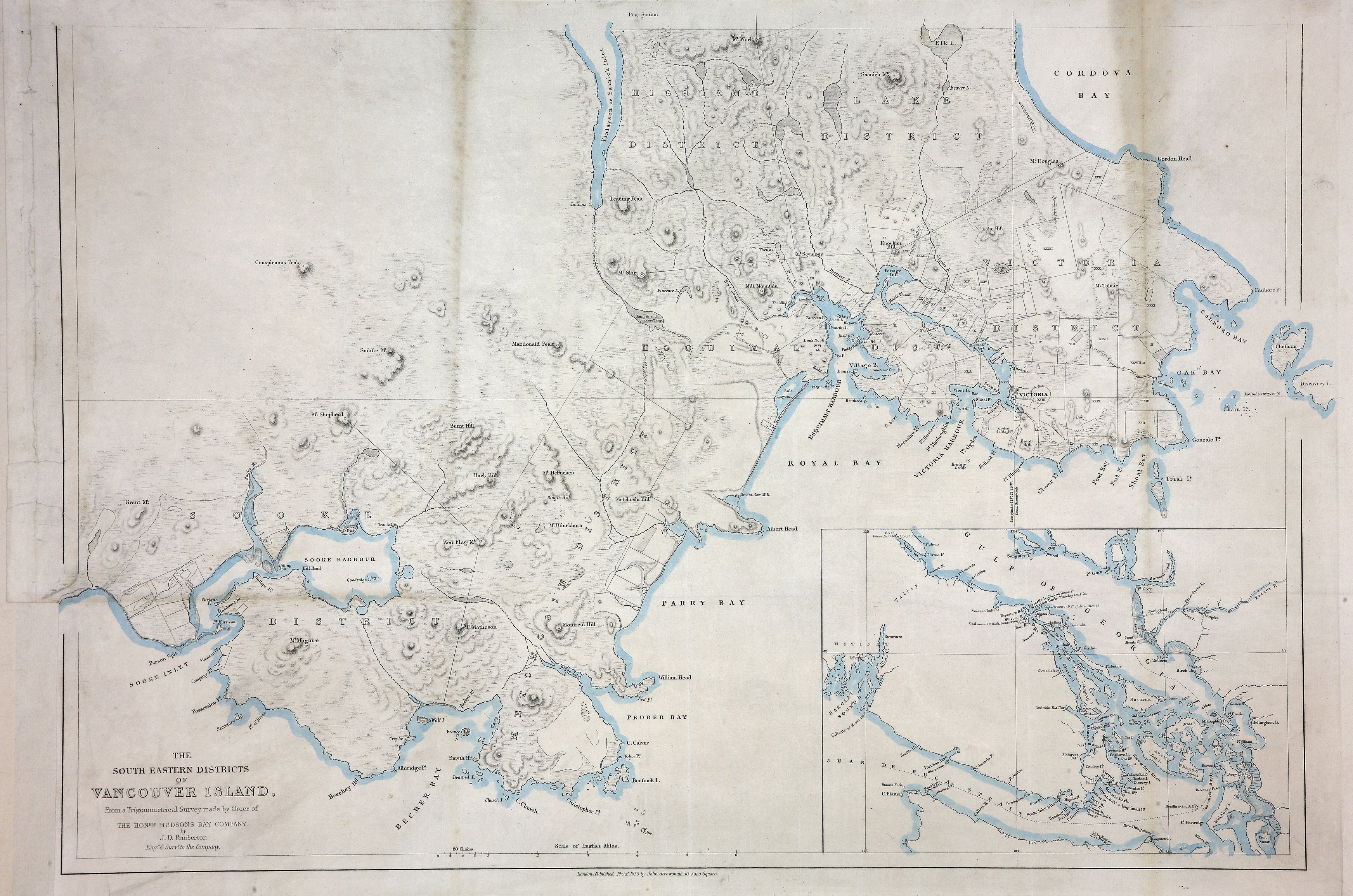
1 item extracted from CO 305/10. 'The South Eastern Districts of Vancouver Island.
From a Trigonometrical Survey made by Order of the Honble. Hudsons Bay Company by
J. D. Pemberton, Eng r. and Surv r. to the Company'. Inset small scale map of the
south-east part of Vancouver Island. Scale: 1 inch to 1 mile. Published 2 October
1855 by John Arrowsmith, 10 Soho Square, London. [Vancouver Island, 1855]. Relief
shown in hachures. Locates some early industries (saw mill, dairy) and First Nations
sites.
Includes the following districts: Victoria, Esquimalt, Lake, Highland, Metchosin and
Sooke. Saanich Districts on other map.
Pemberton, J. Despard (Joseph Despard), 1821-1893., South eastern districts of Vancouver Island, 1855, John Arrowsmith, MPG 1/242. The Colonial Despatches of Vancouver Island and British Columbia 1846-1871, Edition 2.6, ed. James Hendrickson and the Colonial Despatches project. Victoria,
B.C.: University of Victoria. https://bcgenesis.uvic.ca/mpg_1-242_van_isl_1855_bottom_but_separate.html.
Title: South eastern districts of Vancouver Island.
Author: Pemberton, J. Despard (Joseph Despard), 1821-1893.
Subject: Vancouver Island (B.C.) -- Maps; Vancouver Island, Southeastern (B.C.) -- Maps; Indians of North America -- British Columbia -- Vancouver Island.
Subject: Vancouver Island, 1855
Identifier (repository): MPG
Identifier (repoNumber): 1
Identifier (repoVol): 242
Identifier (libFileName): MPG1-242
Identifier (penfoldNum): 567
Identifier (doc_id): MPG 1/242
Date: 1855
Funder: Funded by a Canadian Council of Archives, Archival Community Digitization Program.
Publisher: John Arrowsmith.
Publisher: National Archives of the UK.