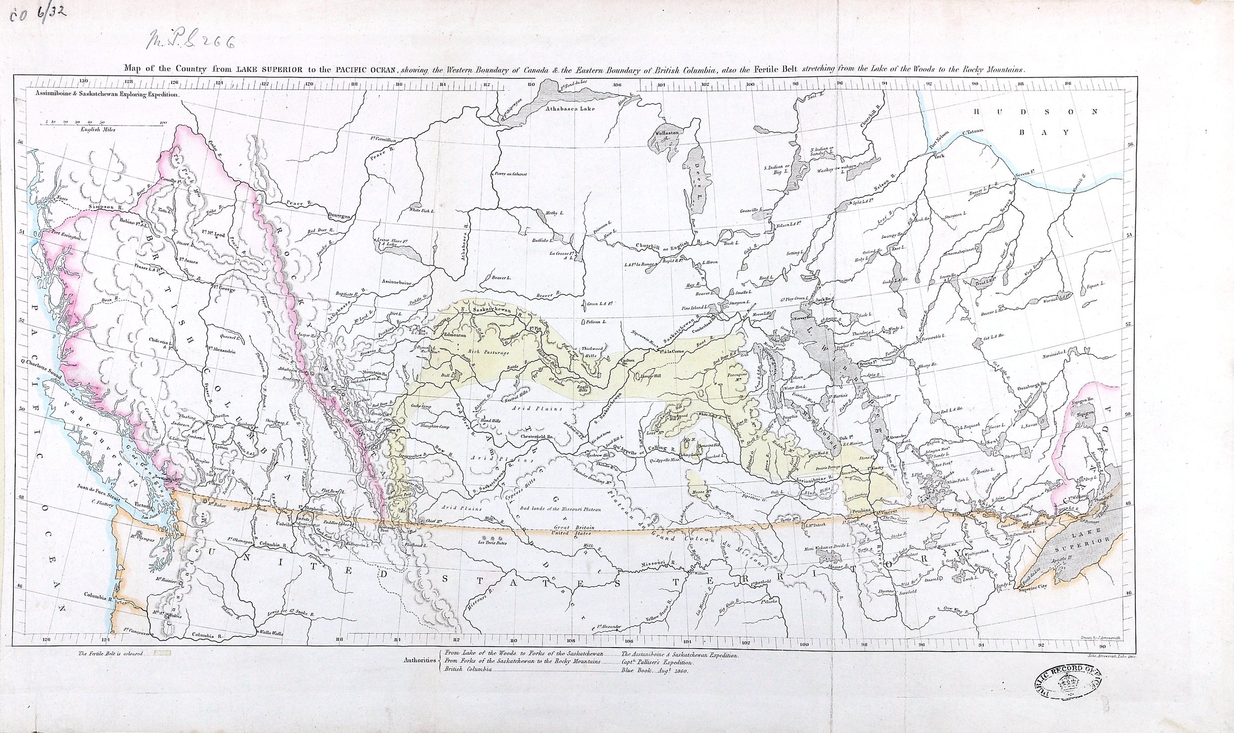
Map of the Country from Lake Superior to the Pacific Ocean, showing the Western Boundary of Canada & the Eastern Boundary of British Columbia, also the Fertile Belt stretching from the Lake of the Woods to the Rocky Mountains.

Map of the Country from Lake Superior to the Pacific Ocean, showing the Western Boundary of Canada & the Eastern Boundary of British Columbia, also the Fertile Belt stretching from the Lake of the Woods to the Rocky Mountains.
1 item (enclosure to Henry Youle Hind's letter (9498 North America) of 24 September 1860) extracted from CO 6/32. 'Map of the Country from Lake Superior to the Pacific Ocean, showing the Western Boundary of Canada & the Eastern Boundary of British Columbia, also the Fertile Belt stretching from the Lake of the Woods to the Rocky Mountains'. Scale: 1 inch to about 90 miles. List of authorities used for the map. Hind was the author of the original map. Drawn and lithographed by John Arrowsmith, 1860.
Hind, Henry Youle, 1823-1908, Map of the Country from Lake Superior to the Pacific Ocean, showing the Western Boundary of Canada & the Eastern Boundary of British Columbia, also the Fertile Belt stretching from the Lake of the Woods to the Rocky Mountains, 1860, National Archives of the UK, MPG 1/266. The Colonial Despatches of Vancouver Island and British Columbia 1846-1871, Edition 2.4, ed. James Hendrickson and the Colonial Despatches project. Victoria, B.C.: University of Victoria. https://bcgenesis.uvic.ca/mpg_1-266_lk_superior_to_pacific_note_co_6_32_1860.html.

Title: Map of the Country from Lake Superior to the Pacific Ocean, showing the Western Boundary of Canada & the Eastern Boundary of British Columbia, also the Fertile Belt stretching from the Lake of the Woods to the Rocky Mountains.

Title: Lake Superior to the Pacific Ocean.

Author: Hind, Henry Youle, 1823-1908

Subject: Canada -- Maps; British Columbia -- Maps; Alberta -- Maps; Saskatchewan -- Maps; Manitoba -- Maps; Ontario -- Maps; Assiniboine and Saskatchewan Exploring Expedition (1858); British North American Exploring Expedition

Identifier (repository): MPG

Identifier (repoNumber): 1

Identifier (repoVol): 266

Identifier (libFileName): MPG1-266

Identifier (penfoldNum):

Identifier (doc_id): MPG 1/266

Date: 1860

Funder: Funded by a Canadian Council of Archives, Archival Community Digitization Program.

Publisher: National Archives of the UK.

Identifier (CONTENTdm): oai:contentdm.library.uvic.ca:collection5/260

57 15'N-45N/127 15'W-84W