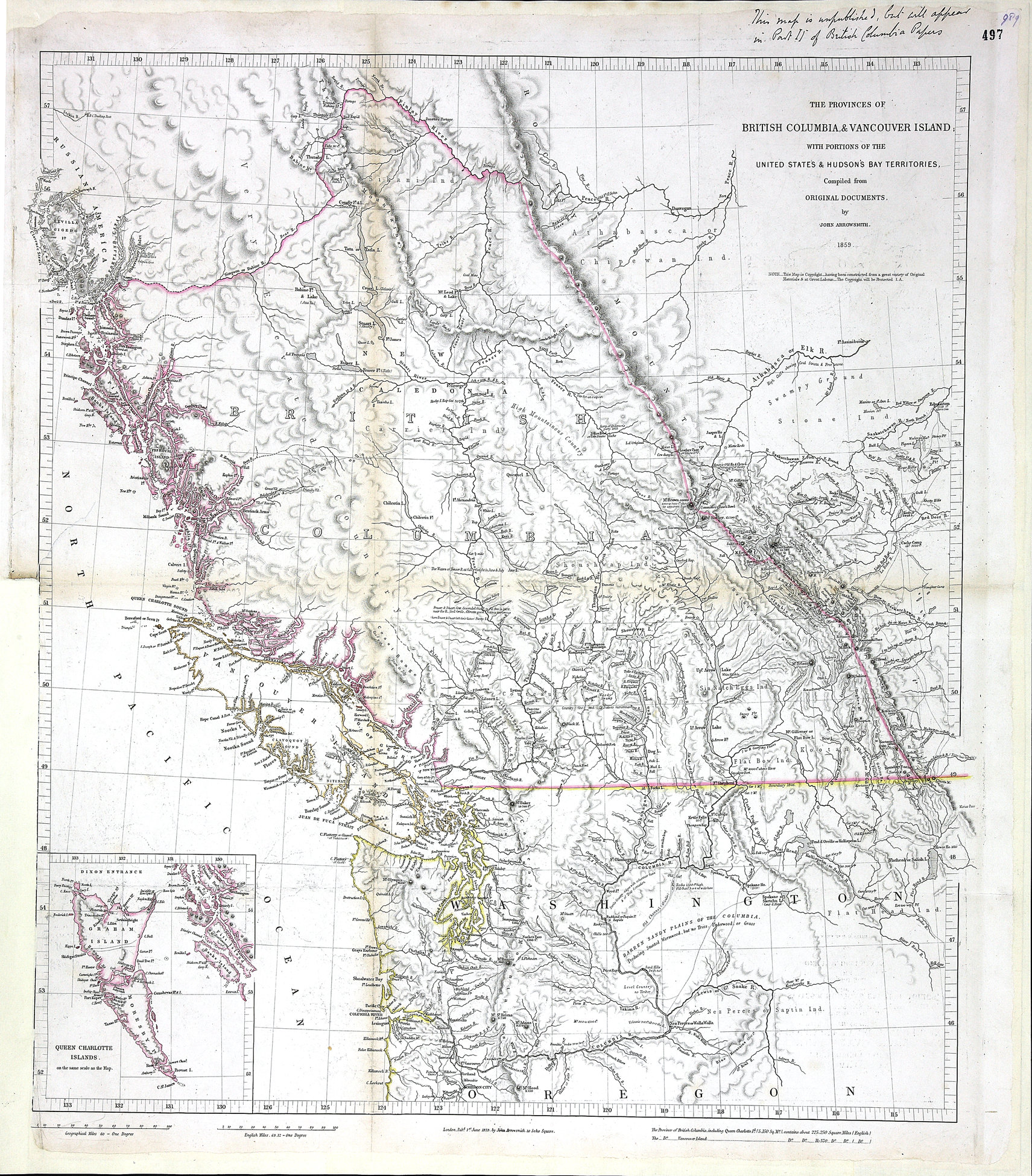
1 item extracted from CO 60/4 (folio 497). 'The Provinces of British Columbia & Vancouver
Island, with Portions of the United States & Hudson's Bay Territories. Compiled from
Original Documents by John Arrowsmith 1859. London. Pubd. 1st. June 1859 by John Arrowsmith
10 Soho Square.' Inset: Queen Charlotte Islands. A note printed below the title states
Arrowsmith's intention of protecting his copyright in the map.A note in the upper
margin reads 'This map is unpublished, but will appear in Part II of British Columbia
Papers'. The area covered comprises present-day British Columbia and parts of Alberta
and Washington state. [British Columbia, 1859]. Descriptive text. Identifies some
First Nations territories.
Arrowsmith, John, 1790-1873.,
Provinces of British Columbia and Vancouver Island; with portions of the United States
and Hudson's Bay Territories, 1859, John Arrowsmith, MPG 1/646.
The Colonial Despatches of Vancouver Island and British Columbia 1846-1871, Edition 2.6, ed. James Hendrickson and the Colonial Despatches project. Victoria,
B.C.: University of Victoria.
https://bcgenesis.uvic.ca/mpg_1-646_bc_and_vi_arrowsmith_1859.html.
Title: Provinces of British Columbia and Vancouver Island; with portions of the United
States and Hudson's Bay Territories.
Author: Arrowsmith, John, 1790-1873.
Subject: British Columbia -- Maps; Vancouver Island -- Maps; Haida Gwaii (B.C.) --
Maps; Washington (State) -- Maps; Oregon -- Maps; Indians of North America -- British
Columbia; Hudsons Bay Company.
Subject: British Columbia, 1859
Identifier (repository): MPG
Identifier (repoNumber): 1
Identifier (repoVol): 646
Identifier (libFileName): MPG1-646
Identifier (penfoldNum): 387
Identifier (doc_id): MPG 1/646
Date: 1859
Funder: Funded by a Canadian Council of Archives, Archival Community Digitization
Program.
Publisher: John Arrowsmith.
Publisher: National Archives of the UK.
View in UVic Libraries Vault repository
57 30'N-45N/132 10'W-112 10'W
