British Columbia. Coast lines from Admiralty Charts, interior from Explorations by Royal Engineers and others up to 1862. North of Fraser River from Mr. Arrowsmith. East of Columbia River from Captain Palliser.

British Columbia. Coast lines from Admiralty Charts, interior from Explorations by Royal Engineers and others up to 1862. North of Fraser River from Mr. Arrowsmith. East of Columbia River from Captain Palliser.
2 items extracted from CO 60/24 (folios 69, 70). Both titled 'British Columbia. Coast lines from Admiralty Charts, interior from Explorations by Royal Engineers and others up to 1862. North of Fraser River from Mr. Arrowsmith. East of Columbia River from Captain Palliser…'. Scale: 1 inch to 50 miles. Reduced and drawn by J Conroy, RE. Prepared under the direction of Capt Parsons, RE, at the Office of Lands & Works, New Westminster, August 1862, by order of R C Moody, Col RE. Lithographed by W Oldham, RE. MS additions show the dioceses of New Westminster and Columbia with Vancouver: on (1) the diocese of Columbia with Vancouver includes the Queen Charlotte Islands and a large tract of mainland British Columbia.
Conroy, James., British Columbia. Coast lines from Admiralty Charts, interior from Explorations by Royal Engineers and others up to 1862. North of Fraser River from Mr. Arrowsmith. East of Columbia River from Captain Palliser, 1862, British Columbia. Dept. of Lands and Works, MPG1-650 (1). The Colonial Despatches of Vancouver Island and British Columbia 1846-1871, Edition 2.4, ed. James Hendrickson and the Colonial Despatches project. Victoria, B.C.: University of Victoria. https://bcgenesis.uvic.ca/mpg_1-650_1_bc_1862.html.

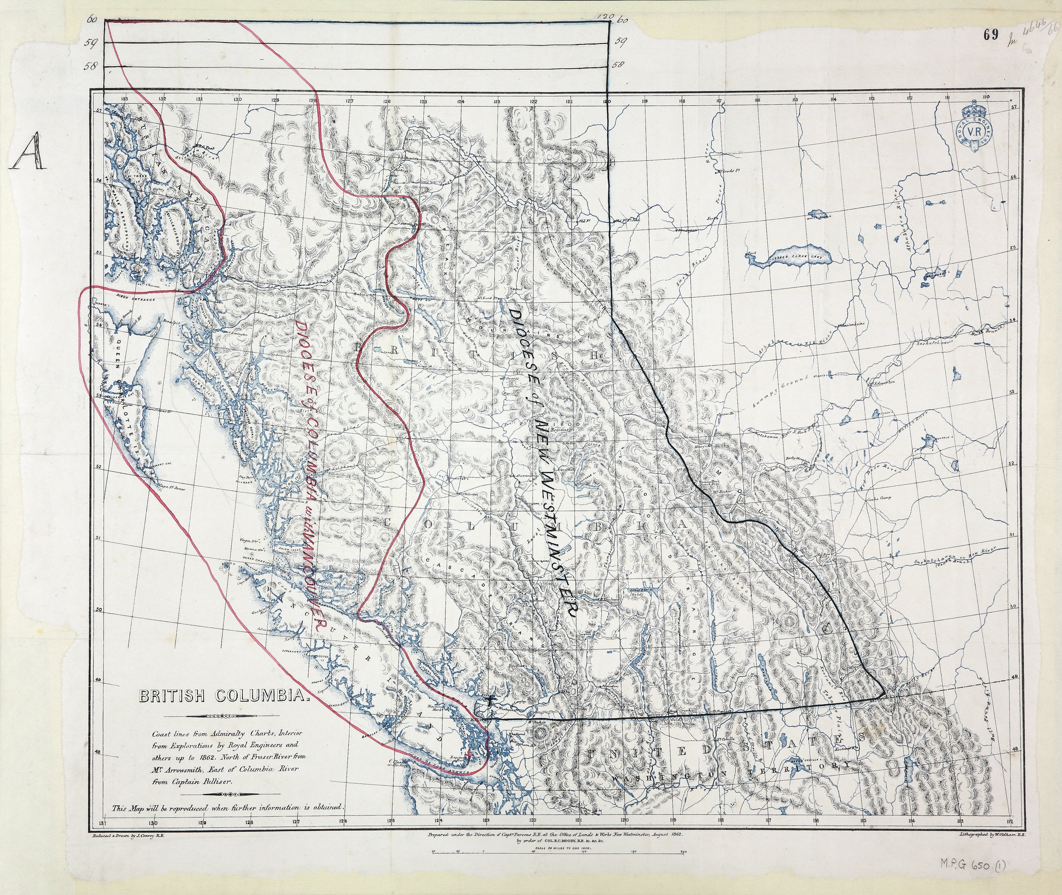
Title: British Columbia. Coast lines from Admiralty Charts, interior from Explorations by Royal Engineers and others up to 1862. North of Fraser River from Mr. Arrowsmith. East of Columbia River from Captain Palliser.

Author: Conroy, James.

Subject: British Columbia -- Maps; Vancouver Island (B.C.) -- Maps; Dioceses.

Identifier (repository): MPG

Identifier (repoNumber): 1

Identifier (repoVol): 650

Identifier (libFileName): MPG1-650 (1)

Identifier (penfoldNum):

Identifier (doc_id): MPG1-650 (1)

Date: 1862

Funder: Funded by a Canadian Council of Archives, Archival Community Digitization Program.

Publisher: British Columbia. Dept. of Lands and Works.

Publisher: National Archives of the UK.

Identifier (CONTENTdm): oai:contentdm.library.uvic.ca:collection5/261

57N-48N/133W-110W
Conroy, James., British Columbia. Coast lines from Admiralty Charts, interior from Explorations by Royal Engineers and others up to 1862. North of Fraser River from Mr. Arrowsmith. East of Columbia River from Captain Palliser, 1862, British Columbia. Dept. of Lands and Works, MPG1-650 (1). The Colonial Despatches of Vancouver Island and British Columbia 1846-1871, Edition 2.4, ed. James Hendrickson and the Colonial Despatches project. Victoria, B.C.: University of Victoria. https://bcgenesis.uvic.ca/mpg_1-650_1_bc_1862.html.
Last modified: 2022-12-15 13:24:22 -0800 (Thu, 15 Dec 2022) (SVN revision: 5648)