Colonial Despatches
The colonial despatches of Vancouver Island and British Columbia 1846-1871
Plan of Fort Victoria, Vancouver's Island, Cammusan Harbour
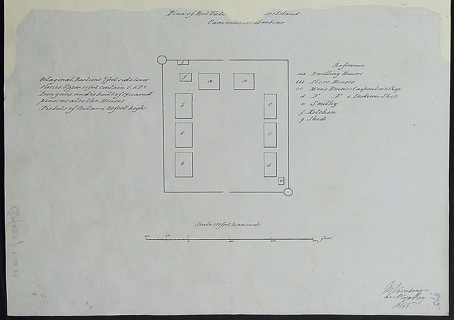
Vancouver Island: Victoria (now in British Columbia). 'Plan of Fort Victoria, Vancouver's
Island, Cammusan Harbour'. Reference table to buildings; and note on armament and
building material. Scale: 1 inch to 100 feet. By Lieutenant M Vavasour, Royal Engineers.
[Victoria, 1845]
Octagonal bastions 5 feet side lower stories. Upper 10 feet contain 6 - 6lb iron guns and is built of squared pine, as also the houses. Pickets of cedar 20 feet high.
Vavasour, M (Mervin), 1821-1866, Plan of Fort Victoria, Vancouver's Island, Cammusan Harbour, 1845, National Archives of the UK, MPHH 1/459/5. The Colonial Despatches of Vancouver Island and British Columbia 1846-1871, Edition 2.6, ed. James Hendrickson and the Colonial Despatches project. Victoria,
B.C.: University of Victoria. https://bcgenesis.uvic.ca/mphh_1-459_pt_1_5_ft_vic_1845.html.
Title: Plan of Fort Victoria, Vancouver's Island, Cammusan Harbour
Title: Fort Victoria, Vancouver Island.
Author: Vavasour, M (Mervin), 1821-1866
Subject: Victoria (B.C.) -- History; Fortification -- British Columbia -- Victoria (B.C.); Architectural drawings.
Subject: Victoria, 1845
Identifier (repository): MPHH
Identifier (repoNumber): 1
Identifier (repoVol): 459
Identifier (libFileName): MPHH1-459 (5)
Identifier (penfoldNum): 575
Identifier (doc_id): MPHH 1/459/5
Date: 1845
Funder: Funded by a Canadian Council of Archives, Archival Community Digitization Program.
Publisher: National Archives of the UK.