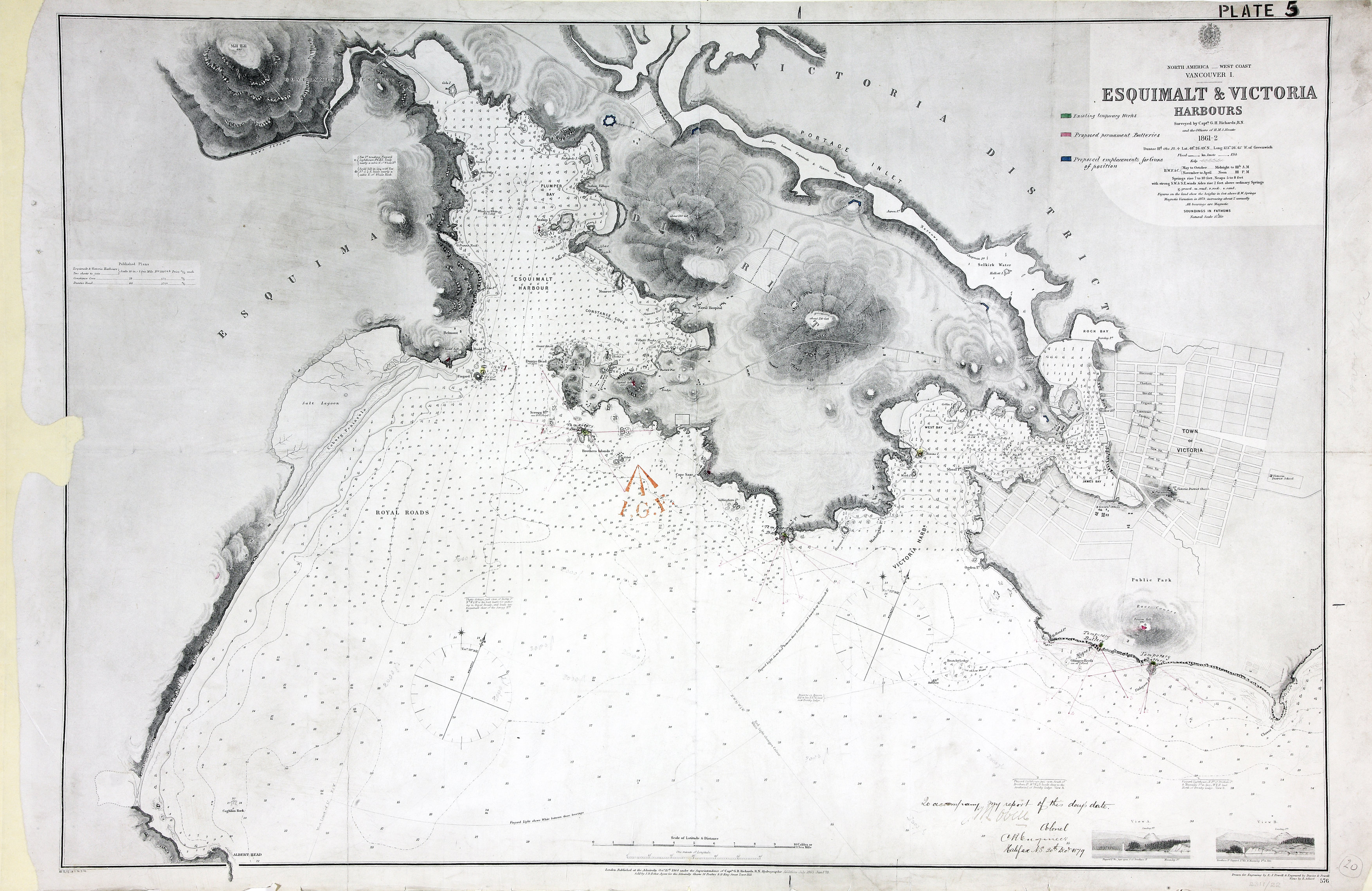
Vancouver Island (subsequently part of British Columbia, now in Canada). Chart: 'Esquimalt
& Victoria Harbours Surveyed by Capt. G. H. Richards, R.N., and the Officers of H.M.S.
Hecate 1861-2…'. Reference table to batteries, emplacements and temporary works. Scale:
1 inch to about 1,000 feet. Compass roses. Drawn for engraving by E J Powell; engraved
by Davies and Powell; published at the Admiralty, 15 October 1864; corrected to 1876.
Insets: views of the coast, by H Adlard. Coloured MS additions show works, and proposed
batteries and gun emplacements, with their ranges and fields of fire. [Esquimalt and
Victoria, 1864; 1876; 1879]
Richards, G. H. (George Henry),
Esquimalt & Victoria Harbours, 1862, Great Britain. Hydrographic Office, WO78-2311 (20).
The Colonial Despatches of Vancouver Island and British Columbia 1846-1871, Edition 2.6, ed. James Hendrickson and the Colonial Despatches project. Victoria,
B.C.: University of Victoria.
https://bcgenesis.uvic.ca/wo_78-2311_20_esq_and_vic_harbours_1862.html.
Title: Esquimalt & Victoria Harbours
Title: North America, West Coast, Vancouver Island, Esquimalt and Victoria Harbours,
surveyed by Capt. G. H. Richards, R.N., and the Officers of H.M.S. Hecate 1861-2.
Author: Richards, G. H. (George Henry)
Subject: Victoria (B.C.)--Maps ; Esquimalt (B.C.)--Maps ; Nautical charts--British
Columbia ; Coast defenses--Canada--History
Subject: Esquimalt and Victoria, 1864, 1876, 1879
Identifier (repository): WO
Identifier (repoNumber): 78
Identifier (repoVol): 2311
Identifier (libFileName): WO78-2311 (20)
Identifier (penfoldNum): 459
Identifier (doc_id): WO78-2311 (20)
Date: 1862
Funder: Funded by a Canadian Council of Archives, Archival Community Digitization
Program.
Publisher: Great Britain. Hydrographic Office
Publisher: National Archives of the UK.
View in UVic Libraries Vault repository