Colonial Despatches
The colonial despatches of Vancouver Island and British Columbia 1846-1871
Esquimalt Harbour.
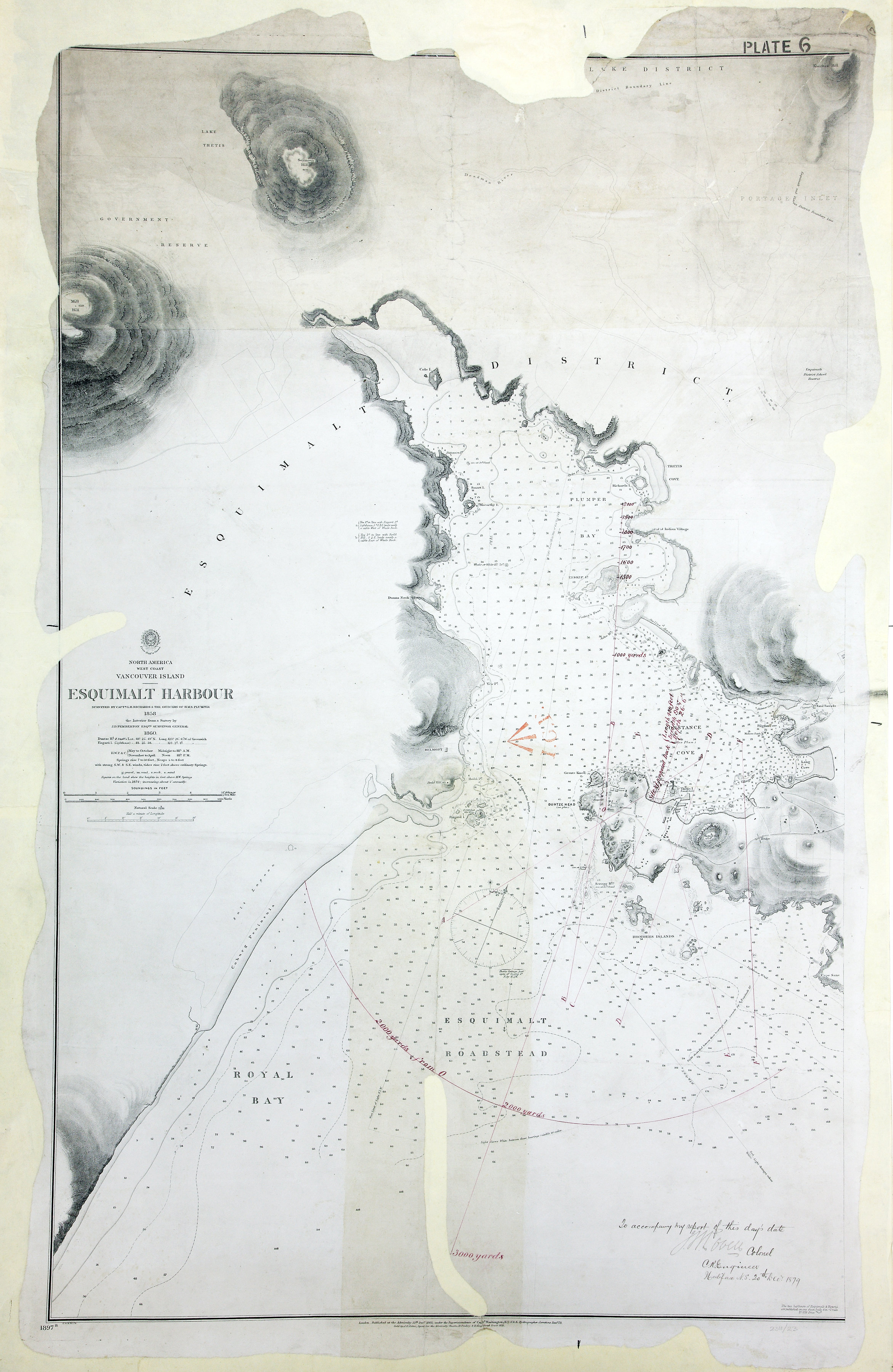
Vancouver Island (subsequently part of British Columbia, now in Canada). Chart: 'Esquimalt
Harbour surveyed by Capt. G. H. Richards & the Officers of H.M.S. Plumper 1858, the
Interior from a Survey by J. D. Pemberton, Esqre., Surveyor General…'. Scale: 1 inch
to about 205 yards. Compass roses. Published at the Admiralty, 13 December 1861; corrected
to 1876. Coloured MS additions show distances and a proposed dock. [Esquimalt, 1861;
1876; 1879]
To accompany my report of this day's date, J.B. Lovell, Colonel C. R. Engineer, Halifax,
N.S. 20th December 1879
Richards, G. H. (George Henry), Esquimalt Harbour, 1860, Great Britain, Hydrographic Office, WO 78/2311/21. The Colonial Despatches of Vancouver Island and British Columbia 1846-1871, Edition 2.6, ed. James Hendrickson and the Colonial Despatches project. Victoria,
B.C.: University of Victoria. https://bcgenesis.uvic.ca/wo_78-2311_21_esq_harbour_1860.html.
Title: Esquimalt Harbour.
Author: Richards, G. H. (George Henry)
Subject: Esquimalt (B.C.)--Maps ; Esquimalt Harbour (B.C.) -- Maps; Harbors -- British Columbia -- Esquimalt ; Nautical charts -- British Columbia -- Esquimalt
Subject: Esquimalt, 1861, 1876, 1879
Identifier (repository): WO
Identifier (repoNumber): 78
Identifier (repoVol): 2311
Identifier (libFileName): WO78-2311 (21)
Identifier (penfoldNum): 457
Identifier (doc_id): WO 78/2311/21
Date: 1860
Funder: Funded by a Canadian Council of Archives, Archival Community Digitization Program.
Publisher: Great Britain, Hydrographic Office
Publisher: National Archives of the UK.